IMAGES TAKEN NEAR TO
Stonedge, Ashover, CHESTERFIELD, S45 0LW
Introduction
This page details the photographs taken nearby to S45 0LW by members of the Geograph project.
The Geograph project started in 2005 with the aim of publishing, organising and preserving representative images for every square kilometre of Great Britain, Ireland and the Isle of Man.

There are currently over 7.5m images from over14,400 individuals and you can help contribute to the project by visiting https://www.geograph.org.uk
Image Map
Images are licensed for reuse under creativecommons.org/licenses/by-sa/2.0
Notes
- Clicking on the map will re-center to the selected point.
- The higher the marker number, the further away the image location is from the centre of the postcode.
Image Listing (46 Images Found)
Images are licensed for reuse under creativecommons.org/licenses/by-sa/2.0
Image
Details
Distance
1
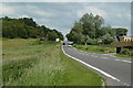
B5057 Darley Road at Stone Edge
View east from the turn for the lane to Stanedge Golf Club.
Image: © Andrew Hill
Taken: 16 Jun 2011
0.01 miles
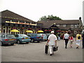
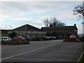
2

Darley Road (B5057)
The Red Lion car park entrance can be seen left of centre.
Image: © Alan Heardman
Taken: 16 Oct 2007
0.03 miles
3
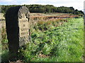
Boundary post , Stone Edge
This boundary post(?) stands alongside the busy B5057 to Chesterfield. Stone Edge Plantation can be seen in the background, where rocky outcrops show the location of a disused quarry.
Image: © Nikki Mahadevan
Taken: 28 Sep 2006
0.04 miles

6

On Darley Road, Stone Edge
On the B5057, at its junction with Belland Lane, looking down this lane which heads towards a golf club. Farmland, a conifer plantation and a rickety footpath sign
Image: © Peter Barr
Taken: 28 Feb 2010
0.08 miles
8
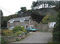
House under rocky outcrop
I think this house is at the entrance to a disused quarry
Image: © Roger Temple
Taken: 27 Sep 2006
0.10 miles