IMAGES TAKEN NEAR TO
Uppertown, CHESTERFIELD, S45 0LS
Introduction
This page details the photographs taken nearby to Uppertown, S45 0LS by members of the Geograph project.
The Geograph project started in 2005 with the aim of publishing, organising and preserving representative images for every square kilometre of Great Britain, Ireland and the Isle of Man.

There are currently over 7.5m images from over14,400 individuals and you can help contribute to the project by visiting https://www.geograph.org.uk
Image Map
Images are licensed for reuse under creativecommons.org/licenses/by-sa/2.0
Notes
- Clicking on the map will re-center to the selected point.
- The higher the marker number, the further away the image location is from the centre of the postcode.
Image Listing (18 Images Found)
Images are licensed for reuse under creativecommons.org/licenses/by-sa/2.0
Image
Details
Distance
1
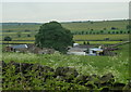
North Brittain farm
View of the farm and surrounding fields from Wirestone Lane.
Image: © Andrew Hill
Taken: 13 Jun 2012
0.00 miles
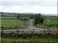
2
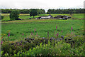
North Brittain Farm
A hill farm viewed from Hodge Lane.
Image: © Bill Boaden
Taken: 6 Jul 2021
0.03 miles
3
North Brittain and holly bush
A farm on Hodge Lane, near Kelstedge
Image: © Peter Barr
Taken: 4 Mar 2010
0.03 miles
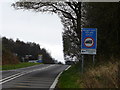
4
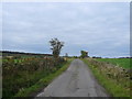
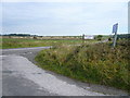
Road junction on Upper Moor
Where Screetham Lane meets the B5057
Image: © Neil Theasby
Taken: 1 Aug 2015
0.13 miles
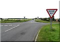
5
Road signs on B5057
Approaching the junction with Screetham Lane
Image: © Graham Hogg
Taken: 20 Oct 2014
0.14 miles
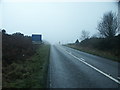
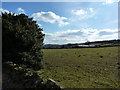
9
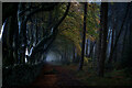
Tree Lined Path
Got some wonderful photos before the mist abated. What a photographic location.
Image: © Brian Deegan
Taken: 29 Oct 2022
0.16 miles