IMAGES TAKEN NEAR TO
Ashover, CHESTERFIELD, S45 0JP
Introduction
This page details the photographs taken nearby to S45 0JP by members of the Geograph project.
The Geograph project started in 2005 with the aim of publishing, organising and preserving representative images for every square kilometre of Great Britain, Ireland and the Isle of Man.

There are currently over 7.5m images from over14,400 individuals and you can help contribute to the project by visiting https://www.geograph.org.uk
Image Map
Images are licensed for reuse under creativecommons.org/licenses/by-sa/2.0
Notes
- Clicking on the map will re-center to the selected point.
- The higher the marker number, the further away the image location is from the centre of the postcode.
Image Listing (26 Images Found)
Images are licensed for reuse under creativecommons.org/licenses/by-sa/2.0
Image
Details
Distance
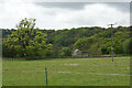
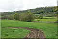
3
Panoramic view from Ravensnest
Ravensnest is a ridge on the west side of the Amber Valley
Image: © Graham Hogg
Taken: 30 Sep 2013
0.08 miles
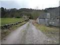
5
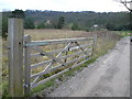
Ravensnest Sign and Lane to Cocking Tor
Image: © Alan Heardman
Taken: 25 Feb 2007
0.09 miles
6
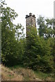
Former lead mine chimney
A fire was set at the foot of the chimney to draw air through the mine.
Image: © Graham Hogg
Taken: 30 Sep 2013
0.14 miles
7
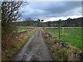
Gin Lane - Section leading from Overton Hall
Approaching Cocking Tor track on left.
Image: © Alan Heardman
Taken: 25 Feb 2007
0.14 miles
8
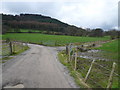
Gin Lane and Cocking Tor
Left lane leads to Cocking Tor, whilst right lane leads to Overton Hall.
Image: © Alan Heardman
Taken: 25 Feb 2007
0.15 miles
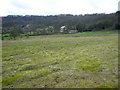
9
Track and path off Gin Lane
The path runs obliquely from near right to far left. Ravensnest Tor overlooks it all.
Image: © Bill Boaden
Taken: 16 May 2021
0.15 miles
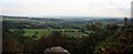
10
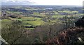
View from Cocking Tor
Ogston Reservoir in distance
Image: © Chris Morgan
Taken: 4 Feb 2014
0.15 miles