IMAGES TAKEN NEAR TO
Coach Road, Overton, CHESTERFIELD, S45 0JN
Introduction
This page details the photographs taken nearby to Coach Road, Overton, S45 0JN by members of the Geograph project.
The Geograph project started in 2005 with the aim of publishing, organising and preserving representative images for every square kilometre of Great Britain, Ireland and the Isle of Man.

There are currently over 7.5m images from over14,400 individuals and you can help contribute to the project by visiting https://www.geograph.org.uk
Image Map
Images are licensed for reuse under creativecommons.org/licenses/by-sa/2.0
Notes
- Clicking on the map will re-center to the selected point.
- The higher the marker number, the further away the image location is from the centre of the postcode.
Image Listing (16 Images Found)
Images are licensed for reuse under creativecommons.org/licenses/by-sa/2.0
Image
Details
Distance
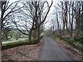
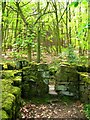
2
Minor lane near Goss Hall
The lane is near the foot of steep wooded hillsides above the upper Amber valley.
Image: © Andrew Hill
Taken: 2 Jun 2012
0.08 miles
3
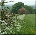
Field edge
A couple of hawthorn bushes in bloom and cow parsley or some other umbellifer in flower by a meadow.
Image: © Andrew Hill
Taken: 2 Jun 2012
0.13 miles
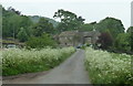
4
Wooded Lane near Goss Hall
The partially obscured dwelling to the left of the road ahead is Overton Lodge.
Image: © Jonathan Clitheroe
Taken: 3 Jan 2011
0.13 miles
5
Footpath joins track near Goss Hall
The footpath joins a track which runs from Goss Hall, past Overton Hall and down to Milltown.
Image: © Nikki Mahadevan
Taken: 13 May 2010
0.13 miles
6
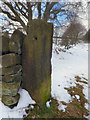
Old Boundary Marker
Parish Boundary Marker in parish of Matlock Town (Derbyshire Dales District), Cuckoostone Lane, gatepost.
surveyed
Milestone Society National ID: DE_MAT02pb.
Image: © Milestone Society
Taken: Unknown
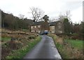
0.13 miles
7
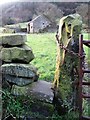
View to an old farm building at Greenend
Image: © Neil Theasby
Taken: 4 Dec 2015
0.15 miles
8
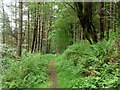
Woodland footpath
The path slants down steep hillside above Goss Hall.
Image: © Andrew Hill
Taken: 2 Jun 2012
0.17 miles
9
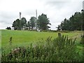
Two of the three masts off Holestone Gate Road
The trees are at the top of a steep hillside.
Image: © Christine Johnstone
Taken: 2 Sep 2016
0.19 miles
10

Farmland and phone masts
Off Holestone Gate Road.
Image: © JThomas
Taken: 28 Jul 2016
0.20 miles