IMAGES TAKEN NEAR TO
Uppertown, CHESTERFIELD, S45 0JD
Introduction
This page details the photographs taken nearby to Uppertown, S45 0JD by members of the Geograph project.
The Geograph project started in 2005 with the aim of publishing, organising and preserving representative images for every square kilometre of Great Britain, Ireland and the Isle of Man.

There are currently over 7.5m images from over14,400 individuals and you can help contribute to the project by visiting https://www.geograph.org.uk
Image Map (Loading...)


Getting Data...Please wait
Leaflet Map data © OpenStreetMap
Images are licensed for reuse under creativecommons.org/licenses/by-sa/2.0
Notes
- Clicking on the map will re-center to the selected point.
- The higher the marker number, the further away the image location is from the centre of the postcode.
Image Listing (18 Images Found)
Images are licensed for reuse under creativecommons.org/licenses/by-sa/2.0
Image
Details
Distance
1
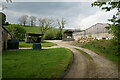
Track at Peasunhurst
Also the route of a footpath passing through the farm.
Image: © Bill Boaden
Taken: 28 May 2021
0.02 miles
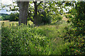
3
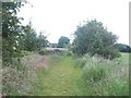
Footpath near Peasunhurst
This picture was taken on an occasionally bright Friday afternoon in late June.
Image: © Jonathan Clitheroe
Taken: 24 Jun 2011
0.03 miles
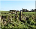
5
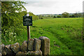
Footpath to Uppertown
Leaving Peasunhurst with the benefit of a Peak & Northern Footpaths Society sign.
Image: © Bill Boaden
Taken: 28 May 2021
0.05 miles
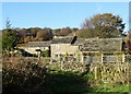
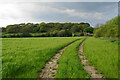
6
Path to Roach House Farm
The path uses the route of an old farm track, but clearly nobody has used it for a while. You are wading through thick undergrowth with a big squelch underneath, and no idea what you are stepping on.
Image: © Bill Boaden
Taken: 6 Jul 2021
0.07 miles
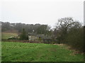
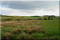
7
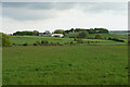
Field near Peasunhurst
Looking towards Bunting Field Farm.
Image: © Bill Boaden
Taken: 28 May 2021
0.09 miles
8
Path to Peasunhurst
Currently following a farm track.
Image: © Bill Boaden
Taken: 28 May 2021
0.11 miles
9
Path to Bunting Field from Peasunhurst
Image: © Neil Theasby
Taken: 14 Nov 2013
0.13 miles
10
Grazing land off Peasunhurst Lane
Only livestock farming is possible here.
Image: © Bill Boaden
Taken: 28 May 2021
0.16 miles