IMAGES TAKEN NEAR TO
Hodge Lane, Uppertown, CHESTERFIELD, S45 0JB
Introduction
This page details the photographs taken nearby to Hodge Lane, Uppertown, S45 0JB by members of the Geograph project.
The Geograph project started in 2005 with the aim of publishing, organising and preserving representative images for every square kilometre of Great Britain, Ireland and the Isle of Man.

There are currently over 7.5m images from over14,400 individuals and you can help contribute to the project by visiting https://www.geograph.org.uk
Image Map
Images are licensed for reuse under creativecommons.org/licenses/by-sa/2.0
Notes
- Clicking on the map will re-center to the selected point.
- The higher the marker number, the further away the image location is from the centre of the postcode.
Image Listing (9 Images Found)
Images are licensed for reuse under creativecommons.org/licenses/by-sa/2.0
Image
Details
Distance
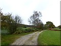
3

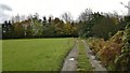
Mole Hills near Kelstedge
On a track to Shooters Lea Farm,looking east towards Ashover.
Are the moles more active this year, has the hard winter had any effect, or is it the case that mole hills were seemingly more visible against the snow?
Image: © Peter Barr
Taken: 4 Mar 2010
0.13 miles
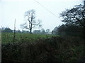
8
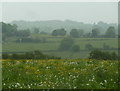
Meadow and view across the valley of Hodgelane Brook
Seen from the path near Shooters Lea Farm.
Image: © Andrew Hill
Taken: 2 Jun 2012
0.23 miles