IMAGES TAKEN NEAR TO
Ashover Road, Stubben Edge, CHESTERFIELD, S45 0EU
Introduction
This page details the photographs taken nearby to Ashover Road, Stubben Edge, S45 0EU by members of the Geograph project.
The Geograph project started in 2005 with the aim of publishing, organising and preserving representative images for every square kilometre of Great Britain, Ireland and the Isle of Man.

There are currently over 7.5m images from over14,400 individuals and you can help contribute to the project by visiting https://www.geograph.org.uk
Image Map
Images are licensed for reuse under creativecommons.org/licenses/by-sa/2.0
Notes
- Clicking on the map will re-center to the selected point.
- The higher the marker number, the further away the image location is from the centre of the postcode.
Image Listing (15 Images Found)
Images are licensed for reuse under creativecommons.org/licenses/by-sa/2.0
Image
Details
Distance
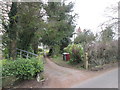
1
Bus stop outside Woodside
The bus stop post and flag is a recent addition to the original sign painted on an old gate post at this isolated property
Image: © Graham Hogg
Taken: 24 Feb 2014
0.00 miles
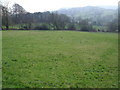
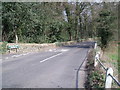
2
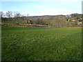
View across Dalebank to Stubben Edge Lane
Image: © Alan Heardman
Taken: 4 Feb 2007
0.09 miles
6
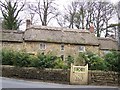
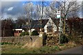
Thatched cottage
This cottage is in Dale Bank near Woolley Moor.
Image: © Tony Hawes
Taken: 20 Apr 2007
0.17 miles
8
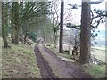
Wooded Track near Edges Farm
Looking south with the Amber valley opening out to the right of shot.
Image: © Jonathan Clitheroe
Taken: 3 Jan 2011
0.17 miles
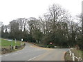
9
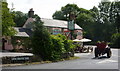
The Nettle pub and an old tractor
The pub is by a junction on the B6036 at Fallgate.
Image: © Andrew Hill
Taken: 24 Jul 2010
0.20 miles
10
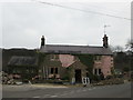
Work in progress at Fallgate
This used to be The Nettle Inn, and before that The Greyhound. Now being converted to housing
Image: © John Slater
Taken: 22 Mar 2016
0.20 miles