IMAGES TAKEN NEAR TO
Slack, Ashover, CHESTERFIELD, S45 0EB
Introduction
This page details the photographs taken nearby to S45 0EB by members of the Geograph project.
The Geograph project started in 2005 with the aim of publishing, organising and preserving representative images for every square kilometre of Great Britain, Ireland and the Isle of Man.

There are currently over 7.5m images from over14,400 individuals and you can help contribute to the project by visiting https://www.geograph.org.uk
Image Map (Loading...)


Getting Data...Please wait
Leaflet Map data © OpenStreetMap
Images are licensed for reuse under creativecommons.org/licenses/by-sa/2.0
Notes
- Clicking on the map will re-center to the selected point.
- The higher the marker number, the further away the image location is from the centre of the postcode.
Image Listing (7 Images Found)
Images are licensed for reuse under creativecommons.org/licenses/by-sa/2.0
Image
Details
Distance
1
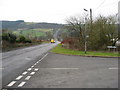
Kelstedge.
A view of Slack Hill from Kelstedge looking towards Matlock.
Image: © Mike Fowkes
Taken: 4 May 2006
0.03 miles
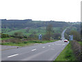
3

View from Vernon Lane, Kelstedge
Looking south up to Amber Hill
Image: © Peter Barr
Taken: 4 Mar 2010
0.05 miles
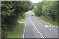
5

Welcome to Kelstedge
Heading north east on Amber Lane (A632).
Image: © JThomas
Taken: 28 Jul 2016
0.17 miles