IMAGES TAKEN NEAR TO
Ashover Road, CHESTERFIELD, S45 0DT
Introduction
This page details the photographs taken nearby to Ashover Road, S45 0DT by members of the Geograph project.
The Geograph project started in 2005 with the aim of publishing, organising and preserving representative images for every square kilometre of Great Britain, Ireland and the Isle of Man.

There are currently over 7.5m images from over14,400 individuals and you can help contribute to the project by visiting https://www.geograph.org.uk
Image Map
Images are licensed for reuse under creativecommons.org/licenses/by-sa/2.0
Notes
- Clicking on the map will re-center to the selected point.
- The higher the marker number, the further away the image location is from the centre of the postcode.
Image Listing (50 Images Found)
Images are licensed for reuse under creativecommons.org/licenses/by-sa/2.0
Image
Details
Distance
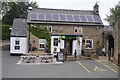
2

Ashover Road (B6036), Kelstedge
Looking south east.
Image: © JThomas
Taken: 28 Jul 2016
0.02 miles
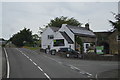
3
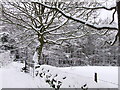
Marsh Green Kelstege, Beech trees in the snow
Image: © stuart dart
Taken: Unknown
0.04 miles
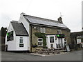
6
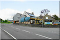
The Kelstedge
Formerly known as The Kelstedge Inn, but is now marketed as a country pub and kitchen. The car park has been filled with erections to allow outside drinking and dining.
Image: © Bill Boaden
Taken: 29 May 2021
0.06 miles