IMAGES TAKEN NEAR TO
Ashover Road, CHESTERFIELD, S45 0BF
Introduction
This page details the photographs taken nearby to Ashover Road, S45 0BF by members of the Geograph project.
The Geograph project started in 2005 with the aim of publishing, organising and preserving representative images for every square kilometre of Great Britain, Ireland and the Isle of Man.

There are currently over 7.5m images from over14,400 individuals and you can help contribute to the project by visiting https://www.geograph.org.uk
Image Map
Images are licensed for reuse under creativecommons.org/licenses/by-sa/2.0
Notes
- Clicking on the map will re-center to the selected point.
- The higher the marker number, the further away the image location is from the centre of the postcode.
Image Listing (21 Images Found)
Images are licensed for reuse under creativecommons.org/licenses/by-sa/2.0
Image
Details
Distance
1
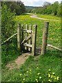
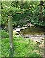
Footpath crossing near Ashover
The path ahead follows the River Amber and the path to the left crosses it.
Image: © Nikki Mahadevan
Taken: 13 May 2010
0.06 miles
2
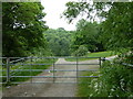
Track leaving the Ashover road
The public path goes straight ahead, using an access point just to the right of the picture. The road is on a narrow twisting section by a bridge.
Image: © Andrew Hill
Taken: 2 Jun 2012
0.06 miles
3
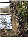
Bench Mark
Bench Mark on Ashover Road Kelstedge
Image: © Andrew Hardwick
Taken: 13 Feb 2021
0.07 miles
4
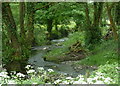
River Amber near Ashover
View from close to some stepping stones.
Image: © Andrew Hill
Taken: 2 Jun 2012
0.09 miles
5
Stepping stones across the River Amber
Footpath crosses the River Amber via stepping stones and leads up through woodland, eventually joining a roadway between Goss Hall and Overton Hall.
Image: © Nikki Mahadevan
Taken: 13 May 2010
0.09 miles
6
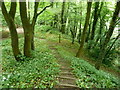
Steep woodland footpath to the River Amber
The path has steep steps near an old quarry.
Image: © Andrew Hill
Taken: 2 Jun 2012
0.10 miles
7
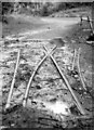
Ashover Light Railway track at Butts Quarry
The Ashover Light Railway was built by the Clay Cross Company, using 60cm-gauge war surplus engines and wagons, and opened in 1925. The passenger service ended in 1936, but the railway continued to carry minerals to Clay Cross Works until 1950. The rails of a point on the bridge over the Amber at the entrance to Butts Quarry were still in place in 1996. For more about the ALR, see http://en.wikipedia.org/wiki/Ashover_Light_Railway and http://www.alrs.org.uk/site/ .
Image: © John Sutton
Taken: Unknown
0.11 miles
8
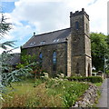
Converted church by Butts Road
The roadside church has been converted into an impressive dwelling.
Image: © Andrew Hill
Taken: 24 Jul 2010
0.16 miles
9

Countryside view from Butts Road
A gateway and field overlooking the Amber valley, by the side of the B6036 on the edge of Ashover.
Image: © Andrew Hill
Taken: 24 Jul 2010
0.16 miles
10
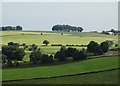
Amber Valley View - from Eddlestow Lot
Image: © Neil Theasby
Taken: 30 Jun 2014
0.17 miles