IMAGES TAKEN NEAR TO
Milken Lane, Far Hill, CHESTERFIELD, S45 0BA
Introduction
This page details the photographs taken nearby to Milken Lane, Far Hill, S45 0BA by members of the Geograph project.
The Geograph project started in 2005 with the aim of publishing, organising and preserving representative images for every square kilometre of Great Britain, Ireland and the Isle of Man.

There are currently over 7.5m images from over14,400 individuals and you can help contribute to the project by visiting https://www.geograph.org.uk
Image Map
Images are licensed for reuse under creativecommons.org/licenses/by-sa/2.0
Notes
- Clicking on the map will re-center to the selected point.
- The higher the marker number, the further away the image location is from the centre of the postcode.
Image Listing (24 Images Found)
Images are licensed for reuse under creativecommons.org/licenses/by-sa/2.0
Image
Details
Distance
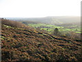
1
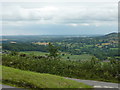
View from Hilltop Lane
Overlooking Farhill, and the Amber Valley, near Ashover.
Image: © Peter Barr
Taken: 28 Jul 2010
0.04 miles
2
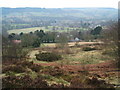
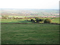
Eastwood Grange from Farhill
Ashover in background
Image: © Peter Barr
Taken: 19 Feb 2009
0.07 miles

7
View Towards Holmgate and North Wingfield
Image: © Alan Heardman
Taken: 18 Nov 2006
0.07 miles
9
View Towards Ashover Hay and Highoredish
Image: © Alan Heardman
Taken: 18 Nov 2006
0.07 miles
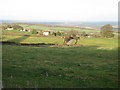
10
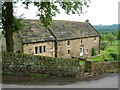
House at Farhill, overlooking the Amber Valley
Image: © John H Darch
Taken: 31 May 2006
0.11 miles