IMAGES TAKEN NEAR TO
Welbeck Road, CHESTERFIELD, S44 6XF
Introduction
This page details the photographs taken nearby to Welbeck Road, S44 6XF by members of the Geograph project.
The Geograph project started in 2005 with the aim of publishing, organising and preserving representative images for every square kilometre of Great Britain, Ireland and the Isle of Man.

There are currently over 7.5m images from over14,400 individuals and you can help contribute to the project by visiting https://www.geograph.org.uk
Image Map
Images are licensed for reuse under creativecommons.org/licenses/by-sa/2.0
Notes
- Clicking on the map will re-center to the selected point.
- The higher the marker number, the further away the image location is from the centre of the postcode.
Image Listing (6 Images Found)
Images are licensed for reuse under creativecommons.org/licenses/by-sa/2.0
Image
Details
Distance
1
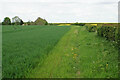
Footpath near Keepers Hollow
The path links Elmton Lane and Marlpit Lane.
Image: © Bill Boaden
Taken: 8 May 2022
0.10 miles
2
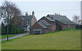
Highfield House off Marlpit Lane
Set back from the lane on the high ground east of Bolsover.
Image: © Andrew Hill
Taken: 18 Nov 2010
0.15 miles
3
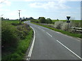
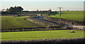
Marlpit Lane
Heading west towards Bolsover.
Image: © JThomas
Taken: 18 Apr 2014
0.22 miles
4
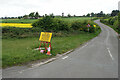
Marlpit Lane
A pleasant rural lane, but the impending temporary closure relates to new house-building not far round the bend.
Image: © Bill Boaden
Taken: 8 May 2022
0.22 miles
5
Marlpit Lane from the B6417
Looking across the gridline to a back lane to Bolsover.
Image: © Andrew Hill
Taken: 20 Jan 2011
0.23 miles
6
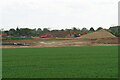
Excavators at work on Destination 14
Part of a large northwards expansion of Bolsover.
Image: © Bill Boaden
Taken: 8 May 2022
0.25 miles