IMAGES TAKEN NEAR TO
Highfield Road, CHESTERFIELD, S44 6TY
Introduction
This page details the photographs taken nearby to Highfield Road, S44 6TY by members of the Geograph project.
The Geograph project started in 2005 with the aim of publishing, organising and preserving representative images for every square kilometre of Great Britain, Ireland and the Isle of Man.

There are currently over 7.5m images from over14,400 individuals and you can help contribute to the project by visiting https://www.geograph.org.uk
Image Map
Images are licensed for reuse under creativecommons.org/licenses/by-sa/2.0
Notes
- Clicking on the map will re-center to the selected point.
- The higher the marker number, the further away the image location is from the centre of the postcode.
Image Listing (126 Images Found)
Images are licensed for reuse under creativecommons.org/licenses/by-sa/2.0
Image
Details
Distance
1
Bolsover - Searson Avenue looking South east
The large building on the skyline is a residential home on the outskirts of Hillstown.
Image: © Gordon Elliott
Taken: 17 Oct 2009
0.03 miles
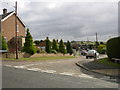
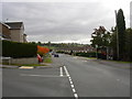
2
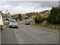
Bolsover - Highfield Road looking East north east
Residential road; the spire of Bolsover Parish Church can just be seen on the skyline on the left of the picture.
Image: © Gordon Elliott
Taken: 17 Oct 2009
0.03 miles
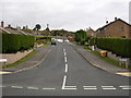
3
Bolsover - Highfield Road looking West south west
Residential road. Using the street light at the bottom of the road as a pointer, ruined Sutton Scarsdale Hall can just about be made out merging with the trees on the horizon. The Hall is now in the care of English Heritage.
Image: © Gordon Elliott
Taken: 17 Oct 2009
0.07 miles
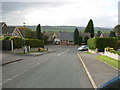
4
Bolsover - Ridgedale Road looking South south east
Residential road, looking towards Palterton on the skyline. The field beyond the last houses is roughly the site of an old railway tunnel between Bolsover and Scarcliffe. It has been filled in for a good many years now.
Image: © Gordon Elliott
Taken: 17 Oct 2009
0.07 miles
5
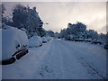
Bolsover - New Station Road
Abandoned cars line the roadside following a heavy fall of snow.
Image: © Gordon Elliott
Taken: 1 Dec 2010
0.08 miles
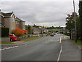
6
Bolsover - Ridgedale Road looking South south east
Residential road, looking towards Palterton on the skyline.
Image: © Gordon Elliott
Taken: 17 Oct 2009
0.08 miles
7
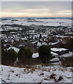
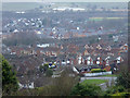
Hillside view, Bolsover
The town centre is on the top of the hill, this view overlooks new housing estates on the hillside and Carr Vale in the valley.
Image: © Andrew Hill
Taken: 25 Dec 2010
0.08 miles
8
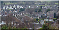
Bolsover housing estate
View from the hilltop footpath. The road "T" junction in view on the right is the end of Highfield Road reaching Ridgedale Road.
Image: © Andrew Hill
Taken: 2 Jan 2013
0.09 miles
9
Bolsover - Ridgedale Road looking North
Residential road to the south side of Bolsover town centre.
Image: © Gordon Elliott
Taken: 17 Oct 2009
0.10 miles
10
Bolsover, hillside houses down to Carr Vale
View near one of the conduit houses on the hilltop footpath. In the lower right hand corner Ridgedale Road leads left from New Station Road. The Doe Lea valley in the background with a couple of the lakes in the Carr Vale reserve in view.
Image: © Andrew Hill
Taken: 2 Jan 2013
0.10 miles