IMAGES TAKEN NEAR TO
Ridgedale Road, CHESTERFIELD, S44 6TX
Introduction
This page details the photographs taken nearby to Ridgedale Road, S44 6TX by members of the Geograph project.
The Geograph project started in 2005 with the aim of publishing, organising and preserving representative images for every square kilometre of Great Britain, Ireland and the Isle of Man.

There are currently over 7.5m images from over14,400 individuals and you can help contribute to the project by visiting https://www.geograph.org.uk
Image Map
Images are licensed for reuse under creativecommons.org/licenses/by-sa/2.0
Notes
- Clicking on the map will re-center to the selected point.
- The higher the marker number, the further away the image location is from the centre of the postcode.
Image Listing (29 Images Found)
Images are licensed for reuse under creativecommons.org/licenses/by-sa/2.0
Image
Details
Distance
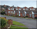
1

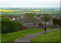
Housing estate, Bolsover
Set on a southwest facing hillside, many of the houses enjoy a good outlook.
Image: © Andrew Hill
Taken: 7 Nov 2010
0.07 miles
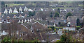
2
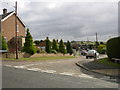
Bolsover - Searson Avenue looking South east
The large building on the skyline is a residential home on the outskirts of Hillstown.
Image: © Gordon Elliott
Taken: 17 Oct 2009
0.11 miles
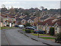
3
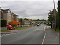
Bolsover - Ridgedale Road looking South south east
Residential road, looking towards Palterton on the skyline. The field beyond the last houses is roughly the site of an old railway tunnel between Bolsover and Scarcliffe. It has been filled in for a good many years now.
Image: © Gordon Elliott
Taken: 17 Oct 2009
0.11 miles
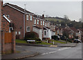
4
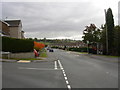
Bolsover - Ridgedale Road looking South south east
Residential road, looking towards Palterton on the skyline.
Image: © Gordon Elliott
Taken: 17 Oct 2009
0.12 miles
5
Towards the top of Bainbridge Road
A modern housing estate is spread across the hillside below the town centre.
Image: © Andrew Hill
Taken: 2 Jan 2013
0.14 miles
6

Overlooking Bolsover
A glimpse of some of the hillside housing from the path skirting the town at the top of the slopes falling away to the west.
Image: © Andrew Hill
Taken: 17 May 2011
0.14 miles
7
Footpath from Conduit Road
There is an extensive modern housing estate on the hillside with good views out to the west. Looking over rooftops on Fairfield Road.
Image: © Andrew Hill
Taken: 16 May 2011
0.15 miles
8
Bolsover housing estate
View from the hilltop footpath. The road "T" junction in view on the right is the end of Highfield Road reaching Ridgedale Road.
Image: © Andrew Hill
Taken: 2 Jan 2013
0.15 miles
9
Conduit Road, Bolsover
The upper part of the modern hillside housing estate south of the town centre.
Image: © Andrew Hill
Taken: 2 Jan 2013
0.15 miles
10
Conduit Road by Eastern Avenue
View south near the top of the hillside housing estate.
Image: © Andrew Hill
Taken: 2 Jan 2013
0.15 miles