IMAGES TAKEN NEAR TO
Rose Hill Court, CHESTERFIELD, S44 6TT
Introduction
This page details the photographs taken nearby to Rose Hill Court, S44 6TT by members of the Geograph project.
The Geograph project started in 2005 with the aim of publishing, organising and preserving representative images for every square kilometre of Great Britain, Ireland and the Isle of Man.

There are currently over 7.5m images from over14,400 individuals and you can help contribute to the project by visiting https://www.geograph.org.uk
Image Map
Images are licensed for reuse under creativecommons.org/licenses/by-sa/2.0
Notes
- Clicking on the map will re-center to the selected point.
- The higher the marker number, the further away the image location is from the centre of the postcode.
Image Listing (155 Images Found)
Images are licensed for reuse under creativecommons.org/licenses/by-sa/2.0
Image
Details
Distance
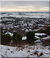
1

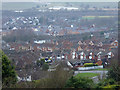
View over Bolsover and Carr Vale
View from the path by the conduit houses at the top of the hillside behind Bolsover High Street. The nearest road is New Station Road reaching the junction with Ridgedale Road. The M1 can be seen in the distance below the field of oil-seed rape.
Image: © Andrew Hill
Taken: 17 May 2011
0.03 miles
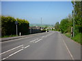
2
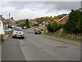
Bolsover - Ridgedale Road looking North
Residential road to the south side of Bolsover town centre.
Image: © Gordon Elliott
Taken: 17 Oct 2009
0.03 miles
3
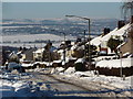
Bolsover, hillside houses down to Carr Vale
View near one of the conduit houses on the hilltop footpath. In the lower right hand corner Ridgedale Road leads left from New Station Road. The Doe Lea valley in the background with a couple of the lakes in the Carr Vale reserve in view.
Image: © Andrew Hill
Taken: 2 Jan 2013
0.03 miles
4
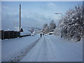
View down New Station Road
Looking down the hill with open views beyond in snowy conditions.
Image: © Andrew Hill
Taken: 5 Dec 2010
0.05 miles
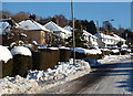
5
Bolsover - New Station Road
Looking down hill. The residential area to the left was even more 'snowed in' with 18 inches (45 cm.) measured by tape rule in my back garden.
Image: © Gordon Elliott
Taken: 1 Dec 2010
0.05 miles
6
Bolsover - New Station Road
What a difference a few months make! Compare this view with Image
Image: © Gordon Elliott
Taken: 18 Apr 2011
0.05 miles
7
Looking up New Station Road
The road was still covered with snow after several days, despite being a busy residential street and on a bus route.
Image: © Andrew Hill
Taken: 5 Dec 2010
0.05 miles
8
Hillside view, Bolsover
The town centre is on the top of the hill, this view overlooks new housing estates on the hillside and Carr Vale in the valley.
Image: © Andrew Hill
Taken: 25 Dec 2010
0.06 miles
9
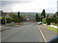
Bolsover - Highfield Road looking West south west
Residential road. Using the street light at the bottom of the road as a pointer, ruined Sutton Scarsdale Hall can just about be made out merging with the trees on the horizon. The Hall is now in the care of English Heritage.
Image: © Gordon Elliott
Taken: 17 Oct 2009
0.07 miles
10

Footpath crossing New Station Road
The path cuts straight down the hillside from the town centre at the top of the hill.
Image: © Andrew Hill
Taken: 17 May 2011
0.07 miles