IMAGES TAKEN NEAR TO
Budget Lane, CHESTERFIELD, S44 6TA
Introduction
This page details the photographs taken nearby to Budget Lane, S44 6TA by members of the Geograph project.
The Geograph project started in 2005 with the aim of publishing, organising and preserving representative images for every square kilometre of Great Britain, Ireland and the Isle of Man.

There are currently over 7.5m images from over14,400 individuals and you can help contribute to the project by visiting https://www.geograph.org.uk
Image Map
Images are licensed for reuse under creativecommons.org/licenses/by-sa/2.0
Notes
- Clicking on the map will re-center to the selected point.
- The higher the marker number, the further away the image location is from the centre of the postcode.
Image Listing (69 Images Found)
Images are licensed for reuse under creativecommons.org/licenses/by-sa/2.0
Image
Details
Distance
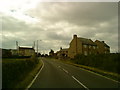
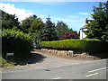
1
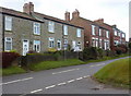
Houses on Main Street, Scarcliffe
Looking across the main street from the end of Budget Lane.
Image: © Andrew Hill
Taken: 8 Jan 2011
0.04 miles
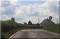
3
The end of Gang Lane, Scarcliffe
The lane (which very close behind becomes a footpath), approaching Scarcliffe Main Street.
Image: © Andrew Hill
Taken: 21 Apr 2012
0.06 miles
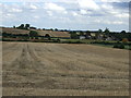
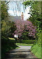
4
North end of Gang Lane, Scarcliffe
Off Main Street.
Image: © Richard Vince
Taken: 25 Jun 2022
0.07 miles