IMAGES TAKEN NEAR TO
Rotherham Road, CHESTERFIELD, S44 6ST
Introduction
This page details the photographs taken nearby to Rotherham Road, S44 6ST by members of the Geograph project.
The Geograph project started in 2005 with the aim of publishing, organising and preserving representative images for every square kilometre of Great Britain, Ireland and the Isle of Man.

There are currently over 7.5m images from over14,400 individuals and you can help contribute to the project by visiting https://www.geograph.org.uk
Image Map
Images are licensed for reuse under creativecommons.org/licenses/by-sa/2.0
Notes
- Clicking on the map will re-center to the selected point.
- The higher the marker number, the further away the image location is from the centre of the postcode.
Image Listing (34 Images Found)
Images are licensed for reuse under creativecommons.org/licenses/by-sa/2.0
Image
Details
Distance
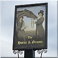
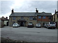
5
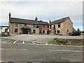
The Horse and Groom
Closed currently due to COVID-19. Not much changed since Image
Image: © David Lally
Taken: 26 May 2020
0.03 miles
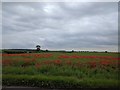
7
Approaching Scarcliffe from Palterton
Western edge of Scarcliffe situated in the eastern extremity of this grid square.
Image: © Jonathan Clitheroe
Taken: 28 Oct 2011
0.05 miles
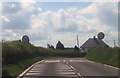
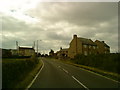
9
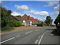
Mansfield Road, Scarcliffe
Entering the village from the south.
Image: © Richard Vince
Taken: 25 Jun 2022
0.11 miles
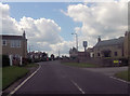
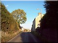
10
New housing off Mansfield Road, Scarcliffe
Accessed via the obligatory unnecessarily bendy cul de sac.
Image: © Richard Vince
Taken: 25 Jun 2022
0.12 miles