IMAGES TAKEN NEAR TO
Limekiln Fields, CHESTERFIELD, S44 6NR
Introduction
This page details the photographs taken nearby to Limekiln Fields, S44 6NR by members of the Geograph project.
The Geograph project started in 2005 with the aim of publishing, organising and preserving representative images for every square kilometre of Great Britain, Ireland and the Isle of Man.

There are currently over 7.5m images from over14,400 individuals and you can help contribute to the project by visiting https://www.geograph.org.uk
Image Map
Images are licensed for reuse under creativecommons.org/licenses/by-sa/2.0
Notes
- Clicking on the map will re-center to the selected point.
- The higher the marker number, the further away the image location is from the centre of the postcode.
Image Listing (14 Images Found)
Images are licensed for reuse under creativecommons.org/licenses/by-sa/2.0
Image
Details
Distance
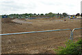
1
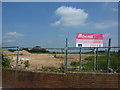
Future building site
Unique countryside dwelling at The Mill; thus says the sign on this proposed development.
Image: © Peter Barr
Taken: 26 Jun 2010
0.07 miles
2
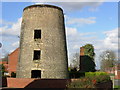
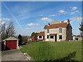
Limekiln Fields Mill
The mill is said to have been built in 1793, from local limestone and sandstone, on an area of Bolsover known as Limekiln Field. It stands, appropriately enough, near the junction of Limekiln Fields Road and Mill Lane, in the garden of a house on a new residential estate called Mill Walk.
Image: © Gordon Elliott
Taken: 4 Mar 2009
0.07 miles
3
Remains of mill and chimney in Bolsover
Image: © John Slater
Taken: 29 May 2019
0.07 miles
4
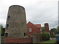
Listed structures on Mill Walk, Bolsover
Both the old mill and the lime kiln chimney are Grade II listed structures. Lime Kiln Fields Mill was built in 1793 from limestone with sandstone. It is a four storey structure and now located in a residential garden. The original machinery used to work the kiln is well preserved inside this derelict, listed building.
Image: © Neil Theasby
Taken: 24 Mar 2014
0.08 miles
5
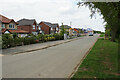
Oxcroft Lane
A new housing estate has appeared on the left opposite the cemetery. An even newer one has been built just beyond that one to the north.
Image: © Bill Boaden
Taken: 8 May 2022
0.13 miles
6
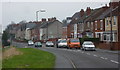
Road heading north out of Bolsover
The B6419 is named Hilltop Avenue in the foreground, becoming Shuttlewood Road beyond the junction with Cundy Road coming up from the left.
Image: © Andrew Hill
Taken: 18 Nov 2010
0.14 miles
8
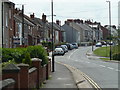
Looking along the B6419 in Bolsover
The road changes from Shuttlewood Road (behind) to Hilltop Avenue (ahead) somewhere in the vicinity.
Image: © Andrew Hill
Taken: 6 Jun 2011
0.17 miles
9

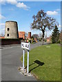
Bolsover Cemetery Maintenance
Off Oxcroft Lane by Limekiln Field.
Image: © Neil Theasby
Taken: 24 Mar 2014
0.18 miles
10
Housing development underway by Oxcroft Lane
This will add to new housing already built on the other side of Oxcroft Lane.
Image: © Bill Boaden
Taken: 8 May 2022
0.19 miles