IMAGES TAKEN NEAR TO
Hill Top, CHESTERFIELD, S44 6NN
Introduction
This page details the photographs taken nearby to Hill Top, S44 6NN by members of the Geograph project.
The Geograph project started in 2005 with the aim of publishing, organising and preserving representative images for every square kilometre of Great Britain, Ireland and the Isle of Man.

There are currently over 7.5m images from over14,400 individuals and you can help contribute to the project by visiting https://www.geograph.org.uk
Image Map
Images are licensed for reuse under creativecommons.org/licenses/by-sa/2.0
Notes
- Clicking on the map will re-center to the selected point.
- The higher the marker number, the further away the image location is from the centre of the postcode.
Image Listing (24 Images Found)
Images are licensed for reuse under creativecommons.org/licenses/by-sa/2.0
Image
Details
Distance
1
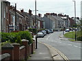
Looking along the B6419 in Bolsover
The road changes from Shuttlewood Road (behind) to Hilltop Avenue (ahead) somewhere in the vicinity.
Image: © Andrew Hill
Taken: 6 Jun 2011
0.05 miles
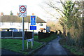
2
Blind Lane, Bolsover
A lovely collection of road signs.
It says it's a dead end, but it isn't.
It says there's no turning space, and there isn't.
It says it's unsuitable for motor vehicles and that's probably fair because it's narrow and breaking up, but we met an unlicensed quad bike.
Why the 30 sign is there was beyond us. Even 10mph down that tarred road would be enough.
Image: © Chris Morgan
Taken: 17 Dec 2013
0.07 miles
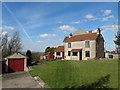
3
Cottages on Blind Lane
It is actually a through road, but I won't be taking my car down it!
Image: © Graham Hogg
Taken: 17 Dec 2013
0.07 miles
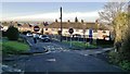
4
Road heading north out of Bolsover
The B6419 is named Hilltop Avenue in the foreground, becoming Shuttlewood Road beyond the junction with Cundy Road coming up from the left.
Image: © Andrew Hill
Taken: 18 Nov 2010
0.08 miles
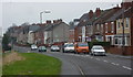
5
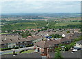
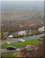
Overlooking Bolsover from Hilltop Road
The northern hillside castle estate stretches across the hillside with former heavy industrial areas in the Doe Lea valley beyond.
Image: © Andrew Hill
Taken: 6 Jun 2011
0.08 miles
7
Bolsover police station
The station is on Limekiln Fields Road, set back a bit from the centre of town.
Image: © Andrew Hill
Taken: 6 Jun 2011
0.11 miles
8
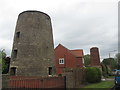
Listed structures on Mill Walk, Bolsover
Both the old mill and the lime kiln chimney are Grade II listed structures. Lime Kiln Fields Mill was built in 1793 from limestone with sandstone. It is a four storey structure and now located in a residential garden. The original machinery used to work the kiln is well preserved inside this derelict, listed building.
Image: © Neil Theasby
Taken: 24 Mar 2014
0.13 miles
9
Remains of mill and chimney in Bolsover
Image: © John Slater
Taken: 29 May 2019
0.14 miles
10
View from Hilltop Avenue
The B6419 runs along the edge of the west facing slope with good views. The two roads in the foreground (in square) are Cundy Road and Houfton Road.
Image: © Andrew Hill
Taken: 18 Nov 2010
0.14 miles