IMAGES TAKEN NEAR TO
Selwyn Street, CHESTERFIELD, S44 6LT
Introduction
This page details the photographs taken nearby to Selwyn Street, S44 6LT by members of the Geograph project.
The Geograph project started in 2005 with the aim of publishing, organising and preserving representative images for every square kilometre of Great Britain, Ireland and the Isle of Man.

There are currently over 7.5m images from over14,400 individuals and you can help contribute to the project by visiting https://www.geograph.org.uk
Image Map
Images are licensed for reuse under creativecommons.org/licenses/by-sa/2.0
Notes
- Clicking on the map will re-center to the selected point.
- The higher the marker number, the further away the image location is from the centre of the postcode.
Image Listing (6 Images Found)
Images are licensed for reuse under creativecommons.org/licenses/by-sa/2.0
Image
Details
Distance
2
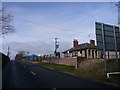
Langwith Road - View of Riding School
Image: © Alan Heardman
Taken: 24 Feb 2008
0.15 miles
3
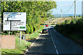
Langwith Road
A632 on the eastern edge of Bolsover.
Image: © David Dixon
Taken: 10 Oct 2022
0.16 miles
4
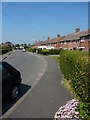
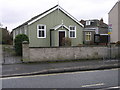
Houses on Langwith Road
Hillstown at the southeastern corner of Bolsover is the highest part of the town.
Image: © Andrew Hill
Taken: 8 Jan 2011
0.18 miles
5
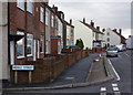
Hillstown Methodist Church
Hillstown Methodist Church is a prefabricated steel clad building which squeezes in between a gap in a row of houses.
Image: © Michael Patterson
Taken: 21 Feb 2006
0.20 miles
6
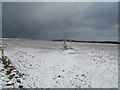
Footpath near Hills Town
A lone dog-walker heading towards Scarcliffe on a particularly cold afternoon in mid March.
Image: © Jonathan Clitheroe
Taken: 11 Mar 2013
0.25 miles