IMAGES TAKEN NEAR TO
Pleasant Avenue, CHESTERFIELD, S44 6LL
Introduction
This page details the photographs taken nearby to Pleasant Avenue, S44 6LL by members of the Geograph project.
The Geograph project started in 2005 with the aim of publishing, organising and preserving representative images for every square kilometre of Great Britain, Ireland and the Isle of Man.

There are currently over 7.5m images from over14,400 individuals and you can help contribute to the project by visiting https://www.geograph.org.uk
Image Map
Images are licensed for reuse under creativecommons.org/licenses/by-sa/2.0
Notes
- Clicking on the map will re-center to the selected point.
- The higher the marker number, the further away the image location is from the centre of the postcode.
Image Listing (6 Images Found)
Images are licensed for reuse under creativecommons.org/licenses/by-sa/2.0
Image
Details
Distance
1
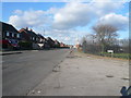
Entering Hillstown on the Mansfield Road
Image: © Alan Heardman
Taken: 30 Jan 2008
0.09 miles
2
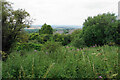
Scrub near Hillstown
A rare view from this section of a footpath which runs south to Palterton. You can see some rooftops of Carr Vale.
Image: © Bill Boaden
Taken: 25 Jul 2021
0.14 miles
3

Footpath towards Palterton
The path has far reaching views to the west, but is very easy level walking itself.
Image: © Andrew Hill
Taken: 17 May 2011
0.16 miles
4
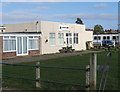
Bolsover - Ace of Clubs
On Mansfield Road, Hillstown.
Image: © Dave Bevis
Taken: 6 Mar 2011
0.19 miles
5
Footpath and Fields between Bolsover and Palterton
Looking towards Palterton from a path which follows a scarp above the Doe Lea Valley.
Image: © Jonathan Clitheroe
Taken: 11 Mar 2013
0.20 miles
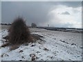
6
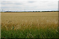
Flat farmland near Hillstown
The top of the hill above the Doe Lea valley.
Image: © Bill Boaden
Taken: 25 Jul 2021
0.23 miles