IMAGES TAKEN NEAR TO
St. Lawrence Avenue, CHESTERFIELD, S44 6HT
Introduction
This page details the photographs taken nearby to St. Lawrence Avenue, S44 6HT by members of the Geograph project.
The Geograph project started in 2005 with the aim of publishing, organising and preserving representative images for every square kilometre of Great Britain, Ireland and the Isle of Man.

There are currently over 7.5m images from over14,400 individuals and you can help contribute to the project by visiting https://www.geograph.org.uk
Image Map
Images are licensed for reuse under creativecommons.org/licenses/by-sa/2.0
Notes
- Clicking on the map will re-center to the selected point.
- The higher the marker number, the further away the image location is from the centre of the postcode.
Image Listing (16 Images Found)
Images are licensed for reuse under creativecommons.org/licenses/by-sa/2.0
Image
Details
Distance
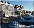
1
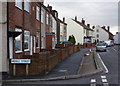
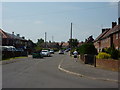
Houses on Langwith Road
Hillstown at the southeastern corner of Bolsover is the highest part of the town.
Image: © Andrew Hill
Taken: 8 Jan 2011
0.07 miles
4
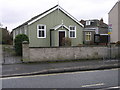
Hillstown Methodist Church
Hillstown Methodist Church is a prefabricated steel clad building which squeezes in between a gap in a row of houses.
Image: © Michael Patterson
Taken: 21 Feb 2006
0.13 miles
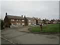
5
Moorfield Avenue, Bolsover
Hot June day, blokes in shorts, workmen doing not much, stretch limo' awaiting celebrity passengers.
Image: © Peter Barr
Taken: 26 Jun 2010
0.16 miles
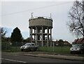
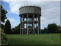
7
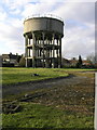
Hillstown Tower
Hillstown water reservoir is operated by Severn Trent Water.
Image: © Michael Patterson
Taken: 17 Feb 2006
0.17 miles
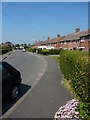
10
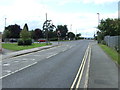
Mansfield Road, Hillstown, after snow
Hillstown is the highest part of Bolsover. This is looking away from the crossroads with Langwith Road, the A632.
Image: © Andrew Hill
Taken: 5 Dec 2010
0.18 miles