IMAGES TAKEN NEAR TO
Leaholme, Chesterfield Road, CHESTERFIELD, S44 6BT
Introduction
This page details the photographs taken nearby to Leaholme, Chesterfield Road, S44 6BT by members of the Geograph project.
The Geograph project started in 2005 with the aim of publishing, organising and preserving representative images for every square kilometre of Great Britain, Ireland and the Isle of Man.

There are currently over 7.5m images from over14,400 individuals and you can help contribute to the project by visiting https://www.geograph.org.uk
Image Map
Images are licensed for reuse under creativecommons.org/licenses/by-sa/2.0
Notes
- Clicking on the map will re-center to the selected point.
- The higher the marker number, the further away the image location is from the centre of the postcode.
Image Listing (15 Images Found)
Images are licensed for reuse under creativecommons.org/licenses/by-sa/2.0
Image
Details
Distance
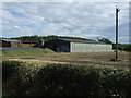
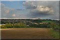
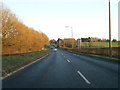
1
Chesterfield Road between Bolsover and Long Duckmanton
Image: © David Dixon
Taken: 14 Oct 2022
0.01 miles
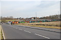
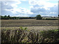
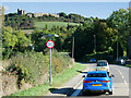
2
On Chesterfield Road west of Bolsover
Near Railway Cottages. You can see Bolsover Castle on the horizon.
Image: © Neil Theasby
Taken: 23 Jan 2017
0.02 miles
3
Bolsover
View of Bolsover with the castle overlooking the town
Image: © Galatas
Taken: 6 Sep 2007
0.02 miles
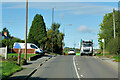
4
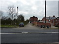
Railway Cottages
Between Long Duckmanton and Bolsover, on the A6192. By a former railway line.
Image: © Peter Barr
Taken: 21 Mar 2011
0.04 miles
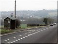
5
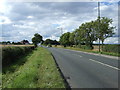
Chesterfield Road (A632)
Heading west towards Chesterfield.
Image: © JThomas
Taken: 7 Sep 2013
0.14 miles
8
Approaching Bolsover
Bolsover Castle on the skyline ahead.
Image: © David Dixon
Taken: 10 Oct 2022
0.17 miles