IMAGES TAKEN NEAR TO
Oxcroft Lane, CHESTERFIELD, S44 6AX
Introduction
This page details the photographs taken nearby to Oxcroft Lane, S44 6AX by members of the Geograph project.
The Geograph project started in 2005 with the aim of publishing, organising and preserving representative images for every square kilometre of Great Britain, Ireland and the Isle of Man.

There are currently over 7.5m images from over14,400 individuals and you can help contribute to the project by visiting https://www.geograph.org.uk
Image Map
Images are licensed for reuse under creativecommons.org/licenses/by-sa/2.0
Notes
- Clicking on the map will re-center to the selected point.
- The higher the marker number, the further away the image location is from the centre of the postcode.
Image Listing (5 Images Found)
Images are licensed for reuse under creativecommons.org/licenses/by-sa/2.0
Image
Details
Distance
1
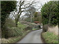
Oxcroft Lane, north of Bolsover
The lane follows the edge of the plateau with the hillside dropping away to the left (west) - often the view being obscured by trees.
Image: © Andrew Hill
Taken: 20 Feb 2012
0.05 miles
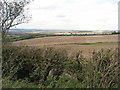
3
Oxcroft Lane Fields
At 540 feet above sea level the views from Oxcroft Lane are spectacular. In the distance on this photo can be seen the M1 between J29 and J30.
Image: © Michael Patterson
Taken: 17 Feb 2006
0.21 miles
4
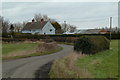
House by Oxcroft Lane
There are some houses and farms scattered along most of the length of the lane north of Bolsover.
Image: © Andrew Hill
Taken: 20 Feb 2012
0.23 miles
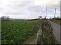
5
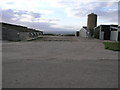
Chicken Sheds
These chicken sheds on Oxcroft Lane appear to be clinging onto the edge of the hill. Beyond the propane tanks the land falls away quickly, some 160 feet in a third of a mile.
Image: © Michael Patterson
Taken: 17 Feb 2006
0.25 miles