IMAGES TAKEN NEAR TO
Appletree Road, CHESTERFIELD, S44 6AJ
Introduction
This page details the photographs taken nearby to Appletree Road, S44 6AJ by members of the Geograph project.
The Geograph project started in 2005 with the aim of publishing, organising and preserving representative images for every square kilometre of Great Britain, Ireland and the Isle of Man.

There are currently over 7.5m images from over14,400 individuals and you can help contribute to the project by visiting https://www.geograph.org.uk
Image Map
Images are licensed for reuse under creativecommons.org/licenses/by-sa/2.0
Notes
- Clicking on the map will re-center to the selected point.
- The higher the marker number, the further away the image location is from the centre of the postcode.
Image Listing (17 Images Found)
Images are licensed for reuse under creativecommons.org/licenses/by-sa/2.0
Image
Details
Distance
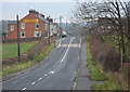
2
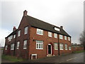
Clowne Road (B6418) and The Appletree Inn
Image: © Alan Heardman
Taken: 24 Feb 2008
0.10 miles
3
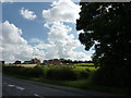
New houses and chicken runs
North of Stanfree, on the B6418 to Clowne.
Image: © Peter Barr
Taken: 28 Jul 2012
0.11 miles
6
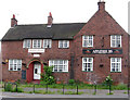
Stanfree - Appletree Inn
Another view is available at Image
Image: © Dave Bevis
Taken: 15 Jun 2010
0.12 miles
8
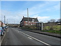
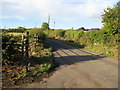
Looking along Clowne Road
Looking northeast along the B6418 past a footpath to the right and to the houses at Bridle Road on the left.
Image: © Andrew Hill
Taken: 18 Nov 2010
0.13 miles