IMAGES TAKEN NEAR TO
Chesterfield Road, CHESTERFIELD, S44 6AD
Introduction
This page details the photographs taken nearby to Chesterfield Road, S44 6AD by members of the Geograph project.
The Geograph project started in 2005 with the aim of publishing, organising and preserving representative images for every square kilometre of Great Britain, Ireland and the Isle of Man.

There are currently over 7.5m images from over14,400 individuals and you can help contribute to the project by visiting https://www.geograph.org.uk
Image Map
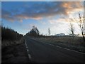
Images are licensed for reuse under creativecommons.org/licenses/by-sa/2.0
Notes
- Clicking on the map will re-center to the selected point.
- The higher the marker number, the further away the image location is from the centre of the postcode.
Image Listing (19 Images Found)
Images are licensed for reuse under creativecommons.org/licenses/by-sa/2.0
Image
Details
Distance
1
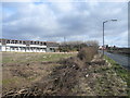
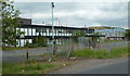
Former Coalite Plant Offices and B6418
Image: © Alan Heardman
Taken: 2 Mar 2008
0.05 miles
2
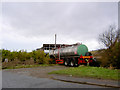
Tanker blocking off one of the many entrances to the former Coalite plant
Taken from the B6418 Buttermilk Lane.
Image: © Steve Fareham
Taken: 6 Dec 2007
0.06 miles
3
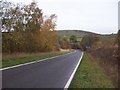
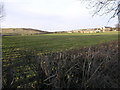
Woodhouse Lane near Bolsover
Looking towards the lane junction with Chesterfield Road on an overcast Saturday morning in early November.
Image: © Jonathan Clitheroe
Taken: 5 Nov 2011
0.06 miles
4
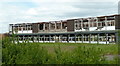
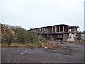
Former offices at the Coalite works
The derelict shell of a former busy, large scale industrial operation.
Image: © Andrew Hill
Taken: 6 Jun 2011
0.08 miles
5
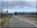
Heading towards Bolsover on Woodhouse Lane
Image: © Steve Fareham
Taken: 11 Dec 2012
0.10 miles
6
Derelict Offices of Industrial Works
Situated at the very south eastern corner of this grid square are the former offices of Coalite Smokeless Fuels. This picture was taken from what was the office car park.
Image: © Jonathan Clitheroe
Taken: 5 Nov 2011
0.10 miles
7
Approaching the former Coalite Site
This shot was taken from a roadside pull-in, on the B6418 just after leaving Shuttlewood. Some buildings on the site, can just be seen through the row of trees on the centre right of picture.
Image: © Alan Heardman
Taken: 2 Mar 2008
0.11 miles
8
Woodhouse Farm
Woodhouse Farm is a neighbour of the former Coalite Chemicals factory. The hill in the background looks very much like one of the many colliery spoil heaps in this area, probably from the former Markham Colliery.
Image: © Michael Patterson
Taken: 3 Mar 2006
0.12 miles
9
Old offices and other industrial buildings, former Coalite works
Some of the old buildings lining Buttermilk Lane, the B6418.
Image: © Andrew Hill
Taken: 6 Jun 2011
0.15 miles
10
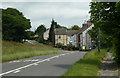
Chesterfield Road and houses
These are the first houses between the former Coalite works and the village of Shuttlewood.
Image: © Andrew Hill
Taken: 6 Jun 2011
0.16 miles