IMAGES TAKEN NEAR TO
Sutton Spring Wood, CHESTERFIELD, S44 5XF
Introduction
This page details the photographs taken nearby to Sutton Spring Wood, S44 5XF by members of the Geograph project.
The Geograph project started in 2005 with the aim of publishing, organising and preserving representative images for every square kilometre of Great Britain, Ireland and the Isle of Man.

There are currently over 7.5m images from over14,400 individuals and you can help contribute to the project by visiting https://www.geograph.org.uk
Image Map
Images are licensed for reuse under creativecommons.org/licenses/by-sa/2.0
Notes
- Clicking on the map will re-center to the selected point.
- The higher the marker number, the further away the image location is from the centre of the postcode.
Image Listing (8 Images Found)
Images are licensed for reuse under creativecommons.org/licenses/by-sa/2.0
Image
Details
Distance
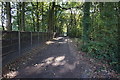
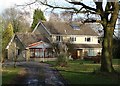
3
Bridleway, footpath
Junction at Sutton Springs Wood.
Image: © Peter Barr
Taken: 24 Feb 2011
0.09 miles
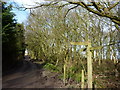
5
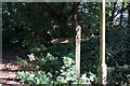
Fingerpost on Rock Lane
At the junction with Postmans Lane.
Image: © Ian S
Taken: 8 Oct 2016
0.11 miles
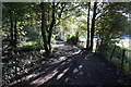
6
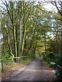
Track near Woodnook Farm
A woodland area east of the B6425, signed as a "bridle road" at the start near Woodnook Farm.
Image: © Andrew Hill
Taken: 6 Nov 2010
0.13 miles
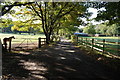
8
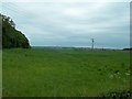
Grassland near Sutton Springs Wood
Image: © Jonathan Clitheroe
Taken: 26 May 2014
0.20 miles