IMAGES TAKEN NEAR TO
Bole Hill, CHESTERFIELD, S44 5UZ
Introduction
This page details the photographs taken nearby to Bole Hill, S44 5UZ by members of the Geograph project.
The Geograph project started in 2005 with the aim of publishing, organising and preserving representative images for every square kilometre of Great Britain, Ireland and the Isle of Man.

There are currently over 7.5m images from over14,400 individuals and you can help contribute to the project by visiting https://www.geograph.org.uk
Image Map
Images are licensed for reuse under creativecommons.org/licenses/by-sa/2.0
Notes
- Clicking on the map will re-center to the selected point.
- The higher the marker number, the further away the image location is from the centre of the postcode.
Image Listing (9 Images Found)
Images are licensed for reuse under creativecommons.org/licenses/by-sa/2.0
Image
Details
Distance
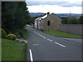
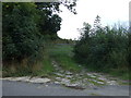
3
Lane at Bolehill
Near the summit of the lane, looking west.
Image: © Andrew Hill
Taken: 6 Nov 2010
0.05 miles
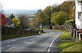
6
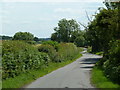
Back Lane near Calow
Looking south along the lane.
Image: © Andrew Hill
Taken: 20 Jun 2011
0.13 miles
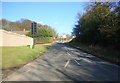
7
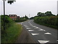
Bolehill
The road at the top of Bolehill hill is painted with teeth which are designed to fool drivers into thinking the road is narrower than it really is. This reminds drivers that they are about to enter a 30 limit.
Image: © Michael Patterson
Taken: 28 Jun 2006
0.16 miles
8
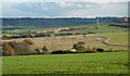
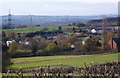
Country views from Bole Hill
Extensive views southeast from Bole Hill. Sutton Scarsdale Hall can be seen on the right edge. Only the nearest part of the foreground is in square.
Image: © Andrew Hill
Taken: 6 Nov 2010
0.18 miles
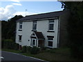
9
View from Back Lane
Looking down over fields to scattered houses around Cock Alley. The two rows of terraced houses are on Dark Lane.
Image: © Andrew Hill
Taken: 6 Nov 2010
0.24 miles