IMAGES TAKEN NEAR TO
Dark Lane, CHESTERFIELD, S44 5UX
Introduction
This page details the photographs taken nearby to Dark Lane, S44 5UX by members of the Geograph project.
The Geograph project started in 2005 with the aim of publishing, organising and preserving representative images for every square kilometre of Great Britain, Ireland and the Isle of Man.

There are currently over 7.5m images from over14,400 individuals and you can help contribute to the project by visiting https://www.geograph.org.uk
Image Map
Images are licensed for reuse under creativecommons.org/licenses/by-sa/2.0
Notes
- Clicking on the map will re-center to the selected point.
- The higher the marker number, the further away the image location is from the centre of the postcode.
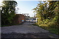
Image Listing (9 Images Found)
Images are licensed for reuse under creativecommons.org/licenses/by-sa/2.0
Image
Details
Distance
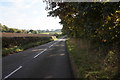
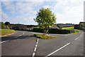
2
View from Cock Alley
Looking westwards along the course a former railway track.
Image: © Neil Theasby
Taken: 30 Jul 2014
0.03 miles
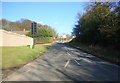
4
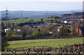
View from Back Lane
Looking down over fields to scattered houses around Cock Alley. The two rows of terraced houses are on Dark Lane.
Image: © Andrew Hill
Taken: 6 Nov 2010
0.03 miles
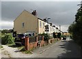
6
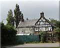
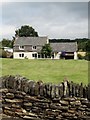
Stanley Cottage in Top Alley
The original timber-framed cottage to the right was built in 1554.
Image: © Neil Theasby
Taken: 30 Jul 2014
0.21 miles