IMAGES TAKEN NEAR TO
Freydon Way, CHESTERFIELD, S44 5TR
Introduction
This page details the photographs taken nearby to Freydon Way, S44 5TR by members of the Geograph project.
The Geograph project started in 2005 with the aim of publishing, organising and preserving representative images for every square kilometre of Great Britain, Ireland and the Isle of Man.

There are currently over 7.5m images from over14,400 individuals and you can help contribute to the project by visiting https://www.geograph.org.uk
Image Map
Images are licensed for reuse under creativecommons.org/licenses/by-sa/2.0
Notes
- Clicking on the map will re-center to the selected point.
- The higher the marker number, the further away the image location is from the centre of the postcode.
Image Listing (9 Images Found)
Images are licensed for reuse under creativecommons.org/licenses/by-sa/2.0
Image
Details
Distance
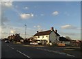
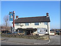
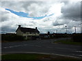
3
The Anvil Pub
Formerly the Blacksmith's Arms which closed c2014 and has reopened as the Anvil.
In its previous incarnation in 2013:- Image
Image: © Stewart Marsh
Taken: 14 Sep 2018
0.07 miles
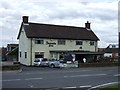
4
Calow - The 'Blacksmiths Arms' on Blacksmith Lane
Image: © Alan Heardman
Taken: 17 Feb 2008
0.07 miles
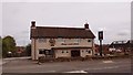
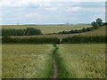
6
Blacksmith's Arms
Pub on Blacksmith Lane, near junction with Church Lane.
Image: © Peter Barr
Taken: 18 Jul 2012
0.08 miles
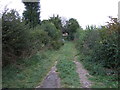
8
Footpath east of Calow
Across fields with links to Inkersall or Arkwright Town.
Image: © Andrew Hill
Taken: 20 Jun 2011
0.19 miles
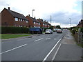
9
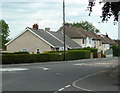
Road junction, Brimington Common
Brimington Common merges with Calow, but they are in different districts. The houses are on Eastmoor Road.
Image: © Andrew Hill
Taken: 20 Jun 2011
0.25 miles