IMAGES TAKEN NEAR TO
Moorland Drive, CHESTERFIELD, S44 5QY
Introduction
This page details the photographs taken nearby to Moorland Drive, S44 5QY by members of the Geograph project.
The Geograph project started in 2005 with the aim of publishing, organising and preserving representative images for every square kilometre of Great Britain, Ireland and the Isle of Man.

There are currently over 7.5m images from over14,400 individuals and you can help contribute to the project by visiting https://www.geograph.org.uk
Image Map
Images are licensed for reuse under creativecommons.org/licenses/by-sa/2.0
Notes
- Clicking on the map will re-center to the selected point.
- The higher the marker number, the further away the image location is from the centre of the postcode.
Image Listing (9 Images Found)
Images are licensed for reuse under creativecommons.org/licenses/by-sa/2.0
Image
Details
Distance
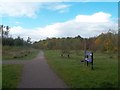
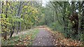
1
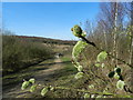
Five Pits Trail
Spring is on the way; pussy willow buds starting to open. This is approaching the site of the former Williamthorpe Colliery. The area used to be fields and woodland until, in 1901, the land was leased to the Hardwick Colliery Company. Coal was mined here till 1970.
Image: © Peter Barr
Taken: 11 Mar 2012
0.10 miles
2
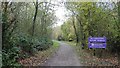
Entering the Williamthorpe Nature Reserve
Walking the Five Pits Trail loop around Holmewood and Williamthorpe
Image : Previous – (7 of 21) - Next : Image
This north-westerly facing photograph of the trail was taken at the point where the trail enters the Williamthorpe Nature Reserve. The trail at this point is following the trackbed of the Great Central Railway.
- - -
The Great Central Railway's route from the south, via Tibshelf, continued on toward Staveley with a branch, at Heath Junction, onto the Chesterfield Loop line.
Image: © Alan Walker
Taken: 31 Oct 2017
0.14 miles
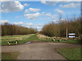
4
The Williamthorpe Nature Reserve
Walking the Five Pits Trail loop around Holmewood and Williamthorpe
Image : Previous – (8 of 21) - Next : Image
This north-westerly facing photograph of the trail was taken inside the Williamthorpe Nature Reserve at the point where it begins to drop down to skirt the northern end of the two main ponds.
- - -
Although landscaping has removed all evidence of the original Great Central Railway's trackbed, it was here, at Heath Junction, where the railway's Chesterfield Loop branch line departed from the main line that continued on toward Staveley.
The Five Pits Trail follows the approximate route of the Chesterfield Loop branch for a short distance before another divergence onto what was the Williamthorpe Colliery Branch line.
See also this photograph by Jonathan Clitheroe:- Image
Image: © Alan Walker
Taken: 31 Oct 2017
0.18 miles
5
The Five Pits Trail near Williamthorpe Ponds
Image: © Jonathan Clitheroe
Taken: 13 Oct 2012
0.20 miles
7
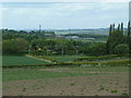
Potato field and northward view
View from the footpath crossing close to the high point southwest of Heath. The farmers will be hoping for plenty of rain, soon.
Image: © Andrew Hill
Taken: 20 May 2011
0.22 miles
8
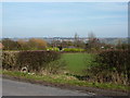
Mansfield Road, from Slack Lane
Bolsover and castle on the horizon.
Image: © Peter Barr
Taken: 24 Feb 2011
0.23 miles
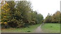
9
The Five Pits Trail Williamthorpe loop
Walking the Five Pits Trail loop around Holmewood and Williamthorpe
Image : Previous – (6 of 21) - Next : Image
This northerly facing photograph of the trail was taken on the approach to Williamthorpe Nature Reserve from Devonshire Terrace (behind the viewpoint). An OS map surveyed in 1914 and published in 1921 shows that the trail at this point is following the trackbed of the Great Central Railway's route from the south, via Tibshelf, that continued on toward Staveley with a branch via Chesterfield.
Beyond the trees on the right of the viewpoint is a small recreation area accessed from Bracken Avenue in Heath.
Image: © Alan Walker
Taken: 31 Oct 2017
0.24 miles