IMAGES TAKEN NEAR TO
Heath Road, CHESTERFIELD, S44 5QT
Introduction
This page details the photographs taken nearby to Heath Road, S44 5QT by members of the Geograph project.
The Geograph project started in 2005 with the aim of publishing, organising and preserving representative images for every square kilometre of Great Britain, Ireland and the Isle of Man.

There are currently over 7.5m images from over14,400 individuals and you can help contribute to the project by visiting https://www.geograph.org.uk
Image Map
Images are licensed for reuse under creativecommons.org/licenses/by-sa/2.0
Notes
- Clicking on the map will re-center to the selected point.
- The higher the marker number, the further away the image location is from the centre of the postcode.
Image Listing (10 Images Found)
Images are licensed for reuse under creativecommons.org/licenses/by-sa/2.0
Image
Details
Distance
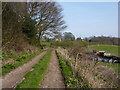
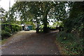
5
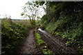
Chapel Hill near Heath
Track near Gildage Farm in Heath, pictured here on a gloomy and overcast afternoon in mid November.
Image: © Jonathan Clitheroe
Taken: 11 Nov 2011
0.21 miles
9
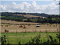
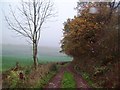
Farmland south of Heath
View across fields and the Doe Lea valley to the Hardwick estate with the hall visible on the skyline right of centre.
Image: © Andrew Hill
Taken: 20 Aug 2012
0.24 miles