IMAGES TAKEN NEAR TO
Waterloo Street, CHESTERFIELD, S44 5PJ
Introduction
This page details the photographs taken nearby to Waterloo Street, S44 5PJ by members of the Geograph project.
The Geograph project started in 2005 with the aim of publishing, organising and preserving representative images for every square kilometre of Great Britain, Ireland and the Isle of Man.

There are currently over 7.5m images from over14,400 individuals and you can help contribute to the project by visiting https://www.geograph.org.uk
Image Map
Images are licensed for reuse under creativecommons.org/licenses/by-sa/2.0
Notes
- Clicking on the map will re-center to the selected point.
- The higher the marker number, the further away the image location is from the centre of the postcode.
Image Listing (23 Images Found)
Images are licensed for reuse under creativecommons.org/licenses/by-sa/2.0
Image
Details
Distance
1
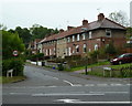
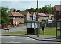
Waterloo Street, Bramley Vale
A row of houses at the edge of the village set off the A617.
Image: © Andrew Hill
Taken: 18 May 2011
0.02 miles
2
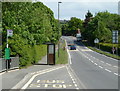
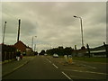
Bus stop on the A617 Mansfield Road at Bramley Vale
The next village is Glapwell, towards Mansfield, on the main road from Chesterfield.
Image: © Andrew Hill
Taken: 20 May 2011
0.06 miles
3

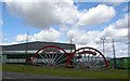
Winding wheels
Glapwell and Bramley Vale drift mines were here once, now the site of a company providing steel cladding systems.
Image: © Peter Barr
Taken: 18 Jul 2010
0.06 miles
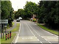
5
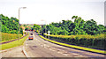
A617 through Bramley Vale
The road dips past the village and then rises to nearby Glapwell.
Image: © Andrew Hill
Taken: 18 May 2011
0.06 miles
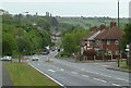
6
Village scene, Bramley Vale
Looking across the main A617 Mansfield Road to Bramley Road and a line of houses on Oxford Street.
Image: © Andrew Hill
Taken: 20 May 2011
0.07 miles
7
On A617 approaching site of Glapwell station, 1998
View eastward at Bramley Vale. Just ahead in the dip the ex-Midland Doe Lea branch, (Chesterfield - Barrow Hill -) Staveley (to left) - (to right) Pleasley - (Mansfield) line, crossed until late 1965. Glapwell station had been on the left and was closed long ago, 28/7/30.
Image: © Ben Brooksbank
Taken: 20 Jun 1998
0.07 miles
9

Memorial to miners lost at Bramley Vale Drift Mine & Glapwell Colliery
Image: © Colin Park
Taken: 1 Oct 2020
0.09 miles
10
Monuments to mining
Glapwell mine and Bramley Vale drift mine.
Image: © Steve Fareham
Taken: 8 Apr 2009
0.09 miles