IMAGES TAKEN NEAR TO
Bolsover Road, CHESTERFIELD, S44 5NJ
Introduction
This page details the photographs taken nearby to Bolsover Road, S44 5NJ by members of the Geograph project.
The Geograph project started in 2005 with the aim of publishing, organising and preserving representative images for every square kilometre of Great Britain, Ireland and the Isle of Man.

There are currently over 7.5m images from over14,400 individuals and you can help contribute to the project by visiting https://www.geograph.org.uk
Image Map
Images are licensed for reuse under creativecommons.org/licenses/by-sa/2.0
Notes
- Clicking on the map will re-center to the selected point.
- The higher the marker number, the further away the image location is from the centre of the postcode.
Image Listing (45 Images Found)
Images are licensed for reuse under creativecommons.org/licenses/by-sa/2.0
Image
Details
Distance
3
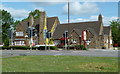
Pub and carvery, Glapwell
By the main road, the "Young Vanish" is named after a 19th century champion race horse (according to Wikipedia).
Image: © Andrew Hill
Taken: 20 May 2011
0.05 miles
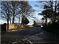
7
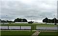
Glapwell Football Club
During the closed season, July.
Image: © Peter Barr
Taken: 18 Jul 2010
0.05 miles
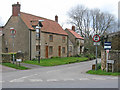
8

The Bolsover road and Back Lane, Glapwell
A farm on the northern edge of the village.
Image: © Andrew Hill
Taken: 15 Oct 2011
0.06 miles