IMAGES TAKEN NEAR TO
Longcourse Lane, CHESTERFIELD, S44 5JB
Introduction
This page details the photographs taken nearby to Longcourse Lane, S44 5JB by members of the Geograph project.
The Geograph project started in 2005 with the aim of publishing, organising and preserving representative images for every square kilometre of Great Britain, Ireland and the Isle of Man.

There are currently over 7.5m images from over14,400 individuals and you can help contribute to the project by visiting https://www.geograph.org.uk
Image Map
Images are licensed for reuse under creativecommons.org/licenses/by-sa/2.0
Notes
- Clicking on the map will re-center to the selected point.
- The higher the marker number, the further away the image location is from the centre of the postcode.
Image Listing (7 Images Found)
Images are licensed for reuse under creativecommons.org/licenses/by-sa/2.0
Image
Details
Distance
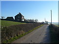
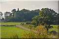
1
Sutton Cum Duckmanton : Longcourse Farm
Looking across the field towards the farm.
Image: © Lewis Clarke
Taken: 20 Sep 2020
0.04 miles
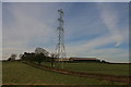
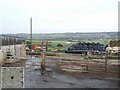
4
Beside the M1 near Junction 29A looking towards Longcourse Farm
Image: © Chris Morgan
Taken: 17 Dec 2013
0.18 miles
5
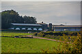
View of M1 and Bolsover from Longcourse Farm
M1 in valley and the town of Bolsover in the distance
Image: © Andrew Jervis
Taken: 5 Nov 2006
0.19 miles
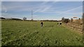
6
Sutton Cum Duckmanton : Grassy Field
Looking across a grassy field with a track heading through.
Image: © Lewis Clarke
Taken: 20 Sep 2020
0.22 miles
7
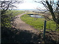
Longcourse Lane - View of Newly Created Footpath
Most of this land was recently outcropped, and a new country park seems to be being created, although it is not yet open.
Image: © Alan Heardman
Taken: 13 Feb 2008
0.24 miles