IMAGES TAKEN NEAR TO
Northcote Way, CHESTERFIELD, S44 5DY
Introduction
This page details the photographs taken nearby to Northcote Way, S44 5DY by members of the Geograph project.
The Geograph project started in 2005 with the aim of publishing, organising and preserving representative images for every square kilometre of Great Britain, Ireland and the Isle of Man.

There are currently over 7.5m images from over14,400 individuals and you can help contribute to the project by visiting https://www.geograph.org.uk
Image Map
Images are licensed for reuse under creativecommons.org/licenses/by-sa/2.0
Notes
- Clicking on the map will re-center to the selected point.
- The higher the marker number, the further away the image location is from the centre of the postcode.
Image Listing (19 Images Found)
Images are licensed for reuse under creativecommons.org/licenses/by-sa/2.0
Image
Details
Distance
1
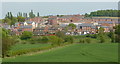
New housing development, Doe Lea
Doe Lea is undergoing expansion with a new housing estate.
Image: © Andrew Hill
Taken: 23 Apr 2011
0.10 miles
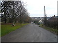
2
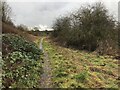
Footpath south of Doe Lea
Heading towards a small footbridge over the river (Doe Lea).
Image: © David Lally
Taken: 7 Jan 2023
0.10 miles
3
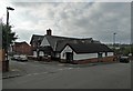
Doe Lea Miners Welfare Social Club, Doe Lea
Image: © Neil Theasby
Taken: 15 Oct 2017
0.12 miles
4
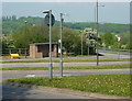
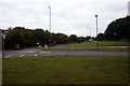
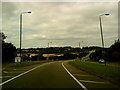
A617 junction, Doe Lea
Various slip roads for buses, left turning and right turning traffic, make this an unusual arrangement.
Image: © Andrew Hill
Taken: 23 Apr 2011
0.14 miles
5
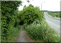
Footpath by the A617
The path leaves the edge of the road and goes along the foot of the embankment which is covered in trees. It leads through to the major motorway roundabout where there is a network of paths and footbridges for walkers avoiding dangerous road crossings.
Image: © Andrew Hill
Taken: 18 May 2011
0.15 miles
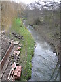
10
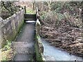
A curious footbridge
Of cement constriction with raised stile-like steps the walls at either side have slots at the bottom. Presumably to let flood water though at time of spate.
Image: © David Lally
Taken: 7 Jan 2023
0.18 miles