IMAGES TAKEN NEAR TO
Staveley Road, CHESTERFIELD, S44 5DS
Introduction
This page details the photographs taken nearby to Staveley Road, S44 5DS by members of the Geograph project.
The Geograph project started in 2005 with the aim of publishing, organising and preserving representative images for every square kilometre of Great Britain, Ireland and the Isle of Man.

There are currently over 7.5m images from over14,400 individuals and you can help contribute to the project by visiting https://www.geograph.org.uk
Image Map
Images are licensed for reuse under creativecommons.org/licenses/by-sa/2.0
Notes
- Clicking on the map will re-center to the selected point.
- The higher the marker number, the further away the image location is from the centre of the postcode.
Image Listing (16 Images Found)
Images are licensed for reuse under creativecommons.org/licenses/by-sa/2.0
Image
Details
Distance
2
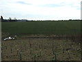
Newly planted trees and farmland
Near Blue Lodge Farm.
Image: © JThomas
Taken: 7 Mar 2015
0.11 miles
3
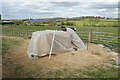
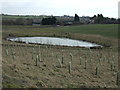
Facilities for horses near Blue Lodge Farm
Duckmanton is on top of the far ridge.
Image: © Bill Boaden
Taken: 18 Apr 2022
0.11 miles
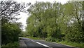
4
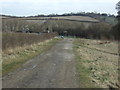
Farm track (footpath) towards Staveley Road
Heading north west.
Image: © JThomas
Taken: 7 Mar 2015
0.12 miles
5
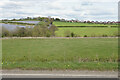
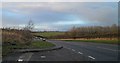
The valley of Pools Brook
Looking east from Staveley Road. Duckmanton is on top of the far ridge. There is a large solar farm to the left.
Image: © Bill Boaden
Taken: 18 Apr 2022
0.12 miles
8
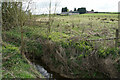
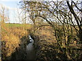
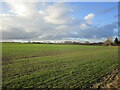
Pools Brook
A tributary of the River Doe Lea. Blue Lodge Farm is behind.
Image: © Bill Boaden
Taken: 18 Apr 2022
0.14 miles