IMAGES TAKEN NEAR TO
Walls Lane, CHESTERFIELD, S43 4TF
Introduction
This page details the photographs taken nearby to Walls Lane, S43 4TF by members of the Geograph project.
The Geograph project started in 2005 with the aim of publishing, organising and preserving representative images for every square kilometre of Great Britain, Ireland and the Isle of Man.

There are currently over 7.5m images from over14,400 individuals and you can help contribute to the project by visiting https://www.geograph.org.uk
Image Map
Images are licensed for reuse under creativecommons.org/licenses/by-sa/2.0
Notes
- Clicking on the map will re-center to the selected point.
- The higher the marker number, the further away the image location is from the centre of the postcode.
Image Listing (5 Images Found)
Images are licensed for reuse under creativecommons.org/licenses/by-sa/2.0
Image
Details
Distance
2
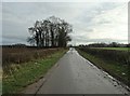
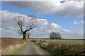
Walls Lane near Eastwood Farm
Looking eastwards from the farm turn-off on a fine April afternoon.
Image: © Jonathan Clitheroe
Taken: 11 Apr 2014
0.13 miles
4
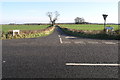
Symmetrical signs
The junction of the A618 and Walls Lane. Despite serving a very small community of mostly farms this short lane has no less than four signs announcing its existence. I couldn't resist a picture since the symmetry of both the signs and the hedges were so appealing. Pity about the lonely Give Way sign.
Image: © Michael Patterson
Taken: 21 Jan 2006
0.21 miles
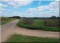
5
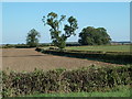
Fields by Walls Lane
The lane heads east of the A618 Rotherham Road.
Image: © Andrew Hill
Taken: 28 Sep 2011
0.21 miles