IMAGES TAKEN NEAR TO
Hardwick Close, CHESTERFIELD, S43 4SL
Introduction
This page details the photographs taken nearby to Hardwick Close, S43 4SL by members of the Geograph project.
The Geograph project started in 2005 with the aim of publishing, organising and preserving representative images for every square kilometre of Great Britain, Ireland and the Isle of Man.

There are currently over 7.5m images from over14,400 individuals and you can help contribute to the project by visiting https://www.geograph.org.uk
Image Map
Images are licensed for reuse under creativecommons.org/licenses/by-sa/2.0
Notes
- Clicking on the map will re-center to the selected point.
- The higher the marker number, the further away the image location is from the centre of the postcode.
Image Listing (18 Images Found)
Images are licensed for reuse under creativecommons.org/licenses/by-sa/2.0
Image
Details
Distance
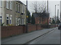
2
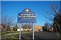
Sacred Heart Church, Clowne
The Sacred Heart Catholic Church on Creswell Road, Clowne.
Image: © Ann B
Taken: 28 Jan 2006
0.14 miles
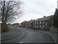
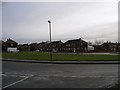
3
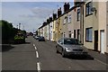
Clowne - Cavendish Drive
Residential estate on the eastern edge of Clowne.
Image: © Gordon Elliott
Taken: 15 Nov 2009
0.15 miles
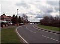
5
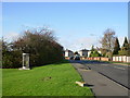
Clowne - Creswell Road
Entering the eastern side of Clowne on the A616.
Image: © Gordon Elliott
Taken: 15 Nov 2009
0.16 miles
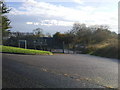
9
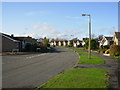
A616 Road in Clowne
Heading out of the village in the direction of Creswell.
Image: © Jonathan Clitheroe
Taken: 17 Mar 2012
0.19 miles