IMAGES TAKEN NEAR TO
Park Street, CHESTERFIELD, S43 4GB
Introduction
This page details the photographs taken nearby to Park Street, S43 4GB by members of the Geograph project.
The Geograph project started in 2005 with the aim of publishing, organising and preserving representative images for every square kilometre of Great Britain, Ireland and the Isle of Man.

There are currently over 7.5m images from over14,400 individuals and you can help contribute to the project by visiting https://www.geograph.org.uk
Image Map
Images are licensed for reuse under creativecommons.org/licenses/by-sa/2.0
Notes
- Clicking on the map will re-center to the selected point.
- The higher the marker number, the further away the image location is from the centre of the postcode.
Image Listing (14 Images Found)
Images are licensed for reuse under creativecommons.org/licenses/by-sa/2.0
Image
Details
Distance
1
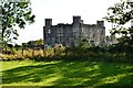
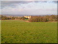
Barlborough Hall
A Grade I listed house originally built by Sir Francis Rodes circa 1583-84 as the family seat. The hall’s Elizabethan design is attributed to Robert Smythson, one of a noted family of architects. Since 1939, the property has been used as a Catholic independent day school feeding Mount St Mary's in nearby Spinkhill.
Image: © Neil Theasby
Taken: 17 Oct 2012
0.01 miles
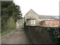
2
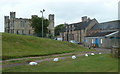
Barlborough Hall School
A view of the buildings from the public footpath passing to the west of the buildings.
Image: © Andrew Hill
Taken: 26 May 2011
0.04 miles
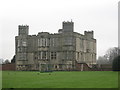
4
Barlborough Hall School
Formerly Barlborough Hall. Built in 1584 by Robert Smithson, who later designed Hardwick Hall
Image: © Stephen Ostler
Taken: 14 Sep 2019
0.05 miles
5
Barlborough Hall
This fine old building was once part of Mount St Mary's R C College at nearby Spinkhill.
Image: © John Poyser
Taken: 3 Dec 2006
0.06 miles
6
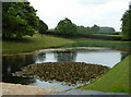
Pond in the grounds of Barlborough Hall School
Glimpsed over the high wall by the Ward lane track.
Image: © Andrew Hill
Taken: 26 May 2011
0.06 miles
7
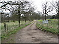
Private track near Barlborough Hall School
Image: © Alan Heardman
Taken: 31 Mar 2009
0.07 miles
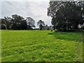
9
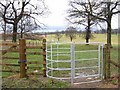
Footpath through the estate of Barlborough Hall
The footpath, which followed Ward Lane from the village of Barlborough, continues over the 320 acre Barlborough Hall estate.
Image: © Nikki Mahadevan
Taken: 10 Feb 2007
0.09 miles
10
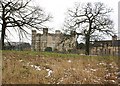
Barlborough Hall School
The school is an independent Jesuit Preparatory School for boys and girls aged 3 - 11. Barlborough Hall is a Grade 1 listed building and was built in 1583 by Francis Rodes.
Image: © Nikki Mahadevan
Taken: 10 Feb 2007
0.13 miles