IMAGES TAKEN NEAR TO
Wilson Avenue, CHESTERFIELD, S43 4AJ
Introduction
This page details the photographs taken nearby to Wilson Avenue, S43 4AJ by members of the Geograph project.
The Geograph project started in 2005 with the aim of publishing, organising and preserving representative images for every square kilometre of Great Britain, Ireland and the Isle of Man.

There are currently over 7.5m images from over14,400 individuals and you can help contribute to the project by visiting https://www.geograph.org.uk
Image Map (Loading...)


Getting Data...Please wait
Leaflet Map data © OpenStreetMap
Images are licensed for reuse under creativecommons.org/licenses/by-sa/2.0
Notes
- Clicking on the map will re-center to the selected point.
- The higher the marker number, the further away the image location is from the centre of the postcode.
Image Listing (18 Images Found)
Images are licensed for reuse under creativecommons.org/licenses/by-sa/2.0
Image
Details
Distance
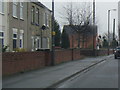
3
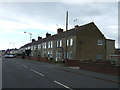
Terraced housing, Clowne
On Creswell Road (A616).
Image: © JThomas
Taken: 28 Aug 2014
0.13 miles
6
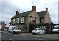
The Travellers Rest, Clowne
On Creswell Road (A616).
Image: © JThomas
Taken: 28 Aug 2014
0.13 miles
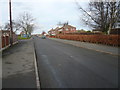
9
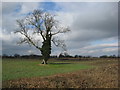
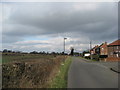
Clowne - View across fields from Hickingwood Lane
Image: © Alan Heardman
Taken: 1 Mar 2009
0.15 miles
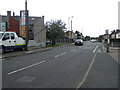
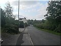
10
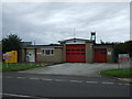
Clowne Fire Station
On Creswell Road (A616).
Image: © JThomas
Taken: 28 Aug 2014
0.16 miles