IMAGES TAKEN NEAR TO
Mallard Court, Lowgates, CHESTERFIELD, S43 3TJ
Introduction
This page details the photographs taken nearby to Mallard Court, Lowgates, S43 3TJ by members of the Geograph project.
The Geograph project started in 2005 with the aim of publishing, organising and preserving representative images for every square kilometre of Great Britain, Ireland and the Isle of Man.

There are currently over 7.5m images from over14,400 individuals and you can help contribute to the project by visiting https://www.geograph.org.uk
Image Map
Images are licensed for reuse under creativecommons.org/licenses/by-sa/2.0
Notes
- Clicking on the map will re-center to the selected point.
- The higher the marker number, the further away the image location is from the centre of the postcode.
Image Listing (50 Images Found)
Images are licensed for reuse under creativecommons.org/licenses/by-sa/2.0
Image
Details
Distance
5
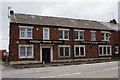
Sheffield British Motorcycles
Lowgates, Staveley.
Image: © Ian S
Taken: 9 Jun 2018
0.08 miles
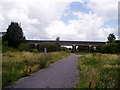
7
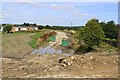
Once the Great Central Railway
Construction of the new road takes place on what was the former Great Central Railway.
Image: © roger geach
Taken: 8 Aug 2009
0.10 miles
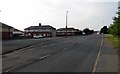
9
Site of Staveley (Central) Station
The station closed in 1963. The railway trackbed is now a cycle path, part of the Trans-Pennine Trail.
Image: © John Armitstead
Taken: 30 Aug 2004
0.12 miles
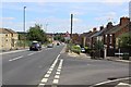
10
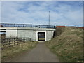
Underpass beneath Lowgates (A619)
Trans Pennine Trail heading north.
Image: © JThomas
Taken: 7 Mar 2015
0.13 miles