IMAGES TAKEN NEAR TO
Denby Road, CHESTERFIELD, S43 3RR
Introduction
This page details the photographs taken nearby to Denby Road, S43 3RR by members of the Geograph project.
The Geograph project started in 2005 with the aim of publishing, organising and preserving representative images for every square kilometre of Great Britain, Ireland and the Isle of Man.

There are currently over 7.5m images from over14,400 individuals and you can help contribute to the project by visiting https://www.geograph.org.uk
Image Map
Images are licensed for reuse under creativecommons.org/licenses/by-sa/2.0
Notes
- Clicking on the map will re-center to the selected point.
- The higher the marker number, the further away the image location is from the centre of the postcode.
Image Listing (7 Images Found)
Images are licensed for reuse under creativecommons.org/licenses/by-sa/2.0
Image
Details
Distance
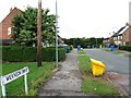
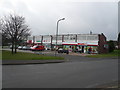
4
Green and shops; Inkersall Green
Brimington.
Image: © Peter Barr
Taken: 31 Jul 2010
0.21 miles
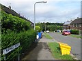
6
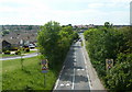
Inkersall Green Road from the old railway bridge
Looking west from the trail along the line of the former railway.
Image: © Andrew Hill
Taken: 2 Jun 2011
0.24 miles
7
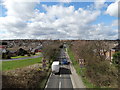
Inkersall Green Road
Seen from an old railway bridge.
Image: © Neil Theasby
Taken: 21 Mar 2014
0.24 miles