IMAGES TAKEN NEAR TO
Fern Avenue, CHESTERFIELD, S43 3RA
Introduction
This page details the photographs taken nearby to Fern Avenue, S43 3RA by members of the Geograph project.
The Geograph project started in 2005 with the aim of publishing, organising and preserving representative images for every square kilometre of Great Britain, Ireland and the Isle of Man.

There are currently over 7.5m images from over14,400 individuals and you can help contribute to the project by visiting https://www.geograph.org.uk
Image Map
Images are licensed for reuse under creativecommons.org/licenses/by-sa/2.0
Notes
- Clicking on the map will re-center to the selected point.
- The higher the marker number, the further away the image location is from the centre of the postcode.
Image Listing (5 Images Found)
Images are licensed for reuse under creativecommons.org/licenses/by-sa/2.0
Image
Details
Distance
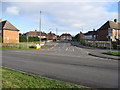
1

Sky Above Middlecroft
At the junction of Cavendish Street and Middlecroft Road, Staveley
Image: © Neil Theasby
Taken: 19 May 2015
0.05 miles
2

Sky above Longshaw Close, Middlecroft, Staveley
Image: © Neil Theasby
Taken: 19 May 2015
0.19 miles
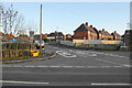
3
Middlecroft - Division Street Junction with A619
Image: © Alan Heardman
Taken: 25 Nov 2008
0.20 miles
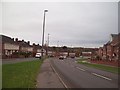
4
Division Street
Access to housing off the A619.
Image: © Bill Boaden
Taken: 15 Dec 2021
0.21 miles
5
Chesterfield Road in Middlecroft
The A619 road approaching Troughbrook Hill in Middlecroft.
Image: © Jonathan Clitheroe
Taken: 5 Nov 2011
0.23 miles