IMAGES TAKEN NEAR TO
Marshfield Grove, CHESTERFIELD, S43 3QD
Introduction
This page details the photographs taken nearby to Marshfield Grove, S43 3QD by members of the Geograph project.
The Geograph project started in 2005 with the aim of publishing, organising and preserving representative images for every square kilometre of Great Britain, Ireland and the Isle of Man.

There are currently over 7.5m images from over14,400 individuals and you can help contribute to the project by visiting https://www.geograph.org.uk
Image Map
Images are licensed for reuse under creativecommons.org/licenses/by-sa/2.0
Notes
- Clicking on the map will re-center to the selected point.
- The higher the marker number, the further away the image location is from the centre of the postcode.
Image Listing (27 Images Found)
Images are licensed for reuse under creativecommons.org/licenses/by-sa/2.0
Image
Details
Distance
1
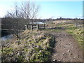
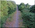
Country Park Footpath and the River Doe Lea
Image: © Alan Heardman
Taken: 6 Feb 2008
0.08 miles
2

Netherthorpe School
The old part of Netherthorpe school near Staveley
Image: © Philip Thompson
Taken: 23 Feb 2002
0.09 miles
5
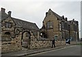
Outside the oldest part of Netherthorpe School
The school was founded in 1572. Now a modern "academy", it has witnessed great changes in the world of education. It's current motto is "Learn. Enjoy. Succeed". It serves over a thousand children from the Staveley area but my photograph shows just one of them.
Image: © Neil Theasby
Taken: 23 Jan 2017
0.11 miles
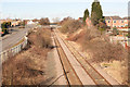
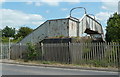
7
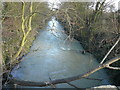
Disused railway line, Staveley
The former coal depot line runs by Fan Lane, seen from a footbridge over the line.
Image: © Andrew Hill
Taken: 2 Jun 2011
0.13 miles
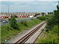
8
Out of use railway at Staveley
Looking towards Barrow Hill this is the out of use railway line from Seymour Yard. No trains have used this line since Oxcroft coal loading point shut around 2006
Image: © roger geach
Taken: 19 Feb 2012
0.13 miles
9
Footbridge from Fan Lane over disused railway
A metal footbridge high over the old coal depot line, Staveley.
Image: © Andrew Hill
Taken: 2 Jun 2011
0.13 miles