IMAGES TAKEN NEAR TO
Poolsbrook Square, CHESTERFIELD, S43 3LD
Introduction
This page details the photographs taken nearby to Poolsbrook Square, S43 3LD by members of the Geograph project.
The Geograph project started in 2005 with the aim of publishing, organising and preserving representative images for every square kilometre of Great Britain, Ireland and the Isle of Man.

There are currently over 7.5m images from over14,400 individuals and you can help contribute to the project by visiting https://www.geograph.org.uk
Image Map
Images are licensed for reuse under creativecommons.org/licenses/by-sa/2.0
Notes
- Clicking on the map will re-center to the selected point.
- The higher the marker number, the further away the image location is from the centre of the postcode.
Image Listing (14 Images Found)
Images are licensed for reuse under creativecommons.org/licenses/by-sa/2.0
Image
Details
Distance
1
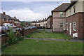
Poolsbrook Crescent
Poolsbrook was built to provide houses for workers at the nearby, now closed, coal mine. The semi-detached house on the right consists of two houses which are built at 90 degrees to each other.
Image: © Michael Patterson
Taken: 10 Jul 2006
0.08 miles
2
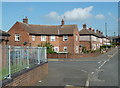
Residential street in Poolsbrook
Looking along Staveley Road past the junction with Poolsbrook Crescent.
Image: © Andrew Hill
Taken: 2 Jun 2011
0.11 miles
3
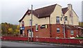
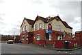
The Poolsbrook Hotel, Cottage Close
Large pub situated close to two former collieries.
Image: © Jonathan Clitheroe
Taken: 5 Nov 2011
0.20 miles
4
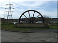
Mining memorial, Poolsbrook Country Park
The winding wheel came from Markham Pit.
Image: © JThomas
Taken: 7 Mar 2015
0.21 miles
5
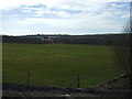
Grazing, Poolsbrook
Looking south west towards the Poolsbrook Hotel public house from the A6192.
Image: © JThomas
Taken: 7 Mar 2015
0.22 miles
6
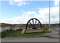
At Pools Brook Country Park
The winding wheel once belonged to Markham Pit. The park was opened in 1999. On the stone plinth there's a bronze plaque which includes these lines - "For never again will the village street/ Echo to the sound of their tramping feet".
Image: © Neil Theasby
Taken: 21 Mar 2014
0.22 miles
7
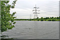
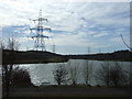
Poolsbrook Lake
In Pools Brook Country Park, created from the old Ireland Colliery site.
Image: © Kate Jewell
Taken: 18 Jun 2010
0.22 miles
8
"The Poolsbrook Hotel", Poolsbrook
Once popular with coal miners and their families, this struggling establishment is now rather like a beached whale. Nearby Markham and Ireland collieries are closed forever and the pub till no longer plays its frenetic tune.
Image: © Neil Theasby
Taken: 21 Mar 2014
0.22 miles
9
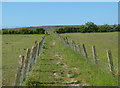
Footpath to Duckmanton
The path used to continue straight ahead, but now does a large westward loop to the right to avoid the open cast workings beyond the rim.
Image: © Andrew Hill
Taken: 2 Jun 2011
0.22 miles