IMAGES TAKEN NEAR TO
Inkersall Road, CHESTERFIELD, S43 3JL
Introduction
This page details the photographs taken nearby to Inkersall Road, S43 3JL by members of the Geograph project.
The Geograph project started in 2005 with the aim of publishing, organising and preserving representative images for every square kilometre of Great Britain, Ireland and the Isle of Man.

There are currently over 7.5m images from over14,400 individuals and you can help contribute to the project by visiting https://www.geograph.org.uk
Image Map
Images are licensed for reuse under creativecommons.org/licenses/by-sa/2.0
Notes
- Clicking on the map will re-center to the selected point.
- The higher the marker number, the further away the image location is from the centre of the postcode.
Image Listing (33 Images Found)
Images are licensed for reuse under creativecommons.org/licenses/by-sa/2.0
Image
Details
Distance
1
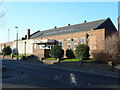
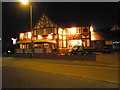
Speedwell Rooms
The Speedwell Rooms viewed from Stephenson Road.
Image: © Tony Bacon
Taken: 6 Feb 2007
0.02 miles
2
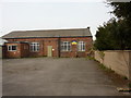
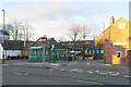
Derbyshire Army Cadet Force, Staveley Detachment
Off Inkersall Road, near the junction with Lime Avenue, a red brick building which was once the Drill Hall used by F Company, 6th Battalion, Sherwood Foresters.
Image: © Peter Barr
Taken: 31 Mar 2014
0.02 miles
3
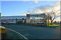
GMH Gruppe
A German company providing steel requirements, with a site on the corner of Stephenson Road and Inkersall Road. The building is illuminated by low winter sun.
Image: © Bill Boaden
Taken: 15 Dec 2021
0.03 miles
4
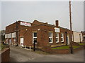
Slimming Club and Table Tennis Academy
On Inkersall Road, Staveley.
Image: © Peter Barr
Taken: 31 Mar 2014
0.04 miles
5
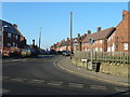
Lime Avenue
Looking West up Lime Avenue across Inkersall Road.
Image: © Tony Bacon
Taken: 6 Feb 2007
0.04 miles
6
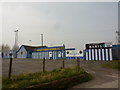
Staveley Miners Welfare FC
The ground, with blue and white colours of Staveley Miners Welfare Football Club who play in the Northern Counties East League Premier Division, at Inkersall Road.
In 1883 a Staveley side beat Sheffield Wednesday 3-1 in the F.A Cup. http://www.staveleyfc.co.uk/history
Image: © Peter Barr
Taken: 31 Mar 2014
0.06 miles
7
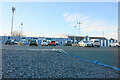
Inkersall Road Football Ground
The home of Staveley Miners Welfare FC which plays in Northern Counties East Football League, Premier Division.
Image: © Bill Boaden
Taken: 15 Dec 2021
0.07 miles
8
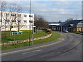
Junction
Road junction of A619 with Inkersall Road with job-centre in background.
Image: © Tony Bacon
Taken: 30 Jan 2007
0.11 miles
10
Market Street bus stop
The main stop for the town centre, at the end of High Street where it meets Market Street.
Image: © Bill Boaden
Taken: 15 Dec 2021
0.13 miles