IMAGES TAKEN NEAR TO
Brindley Way, CHESTERFIELD, S43 3JF
Introduction
This page details the photographs taken nearby to Brindley Way, S43 3JF by members of the Geograph project.
The Geograph project started in 2005 with the aim of publishing, organising and preserving representative images for every square kilometre of Great Britain, Ireland and the Isle of Man.

There are currently over 7.5m images from over14,400 individuals and you can help contribute to the project by visiting https://www.geograph.org.uk
Image Map
Images are licensed for reuse under creativecommons.org/licenses/by-sa/2.0
Notes
- Clicking on the map will re-center to the selected point.
- The higher the marker number, the further away the image location is from the centre of the postcode.
Image Listing (81 Images Found)
Images are licensed for reuse under creativecommons.org/licenses/by-sa/2.0
Image
Details
Distance
1

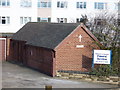
Staveley fire station
Staveley fire station, Crompton Road, Staveley, Derbyshire
Image: © Kevin Hale
Taken: 4 Aug 2010
0.07 miles
2
Staveley (GC) Locomotive Shed, 1964
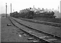
Staveley loco shed (coded 41H by British Railways) was a base for locomotives which hauled coal and steel on the former Great Central lines in North Derbyshire. The two O1 2-8-0s on the left were not in use, but late on a Sunday afternoon in autumn the others seen here were being prepared for the following day. They are, from left to right, A WD Austerity 2-8-0, a 9F 2-10-0 and three 04/8 2-8-0s. Owing to a deteriorating roof the shed building – originally home to 60 locomotives and spanning twelve tracks – was rebuilt and reduced in size in 1951-2. It closed in 1965. The site is now unrecognisable – see Andrew Hill’s Image] and others.
This photo was taken on an epic cycle ride from Nottingham to Staveley and back which also included trips to Annesley (see Image]), Kirkby-in-Ashfield and Langwith Junction (Image]) engine sheds. That was the kind of thing sixth-form lads did on Sundays in those days.
The Midland Railway’s Staveley Barrow Hill engine shed survives as a railway museum – see Image] and many others.
Image: © John Sutton
Taken: 25 Oct 1964
0.08 miles
3
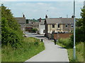
Path to housing estate in Staveley
A new or remade pathway from the new A road to houses on Belmont Drive and beyond.
Image: © Andrew Hill
Taken: 2 Jun 2011
0.09 miles
4
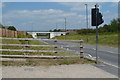
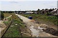
New road through Staveley
A new stretch of the A6192 which does a loop around the east and north of the town. As it stands it is difficult to make sense of the reason for the route, which has no direct link with the busy A619 - it must be part of some larger plan yet to be completed. At present it carries hardly any traffic.
Image: © Andrew Hill
Taken: 2 Jun 2011
0.11 miles
5
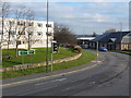
Junction
Road junction of A619 with Inkersall Road with job-centre in background.
Image: © Tony Bacon
Taken: 30 Jan 2007
0.12 miles
6
Chapel of Rest
The Dead Centre Of Staveley?
Image: © Tony Bacon
Taken: 30 Jan 2007
0.13 miles
7
Once the Great Central Railway looking south
Building of the new road continues along the path of the old Great Central railway
Image: © roger geach
Taken: 8 Aug 2009
0.14 miles
9
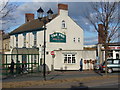
The Pod Public House, Staveley
Oddly named pub off Market Street, Staveley
Image: © Tony Bacon
Taken: 26 Feb 2007
0.15 miles
10
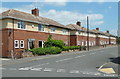
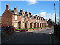
Houses, Barrow Street, Staveley
A street on a traditional residential development.
Image: © Andrew Hill
Taken: 2 Jun 2011
0.15 miles