IMAGES TAKEN NEAR TO
Hillside Drive, CHESTERFIELD, S43 3AE
Introduction
This page details the photographs taken nearby to Hillside Drive, S43 3AE by members of the Geograph project.
The Geograph project started in 2005 with the aim of publishing, organising and preserving representative images for every square kilometre of Great Britain, Ireland and the Isle of Man.

There are currently over 7.5m images from over14,400 individuals and you can help contribute to the project by visiting https://www.geograph.org.uk
Image Map (Loading...)


Getting Data...Please wait
Leaflet Map data © OpenStreetMap
Images are licensed for reuse under creativecommons.org/licenses/by-sa/2.0
Notes
- Clicking on the map will re-center to the selected point.
- The higher the marker number, the further away the image location is from the centre of the postcode.
Image Listing (11 Images Found)
Images are licensed for reuse under creativecommons.org/licenses/by-sa/2.0
Image
Details
Distance
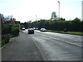
1
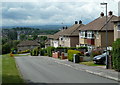
Looking down Hillside Drive, Mastin Moor
The hillside leads down to the Doe Lea valley.
Image: © Andrew Hill
Taken: 26 May 2011
0.05 miles
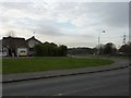
2
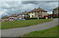
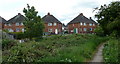
Grassy area and houses, Mastin Moor
The houses are on Cherry Tree Grove. The village has a rather suburban feel.
Image: © Andrew Hill
Taken: 26 May 2011
0.07 miles
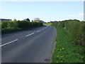
5

Lansbury Avenue, Mastin Moor
North off Worksop Road.
Image: © JThomas
Taken: 18 Apr 2014
0.16 miles
7
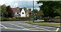
Norbriggs Road junction with the A619
Road junction with nearby houses.
Image: © Andrew Hill
Taken: 26 May 2011
0.21 miles
10
Footpath by the edge of Mastin Moor village
Looking to some of the houses from the footpath skirting the edge of the village.
Image: © Andrew Hill
Taken: 26 May 2011
0.24 miles