IMAGES TAKEN NEAR TO
Brimington, CHESTERFIELD, S43 1QQ
Introduction
This page details the photographs taken nearby to S43 1QQ by members of the Geograph project.
The Geograph project started in 2005 with the aim of publishing, organising and preserving representative images for every square kilometre of Great Britain, Ireland and the Isle of Man.

There are currently over 7.5m images from over14,400 individuals and you can help contribute to the project by visiting https://www.geograph.org.uk
Image Map
Images are licensed for reuse under creativecommons.org/licenses/by-sa/2.0
Notes
- Clicking on the map will re-center to the selected point.
- The higher the marker number, the further away the image location is from the centre of the postcode.
Image Listing (21 Images Found)
Images are licensed for reuse under creativecommons.org/licenses/by-sa/2.0
Image
Details
Distance
1
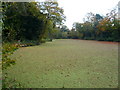
Lake near Tapton Grove
Completely covered with pond weed.
Image: © Alan Heardman
Taken: 28 Oct 2007
0.06 miles
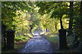
2
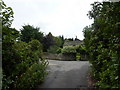
Shrubbery and cottage at Tapton Grange
Near Calow, on the outskirts of Chesterfield.
Image: © Peter Barr
Taken: 31 Jul 2010
0.06 miles
3
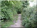
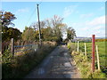
Track to Tapton Grove
This path leads to Tapton Grove and then on to Brimington.
Image: © Michael Patterson
Taken: 13 Sep 2006
0.09 miles
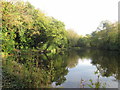
6
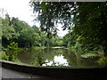
A fishing pond
Near Tapton Grove, Calow, Chesterfield.
Image: © Peter Barr
Taken: 31 Jul 2010
0.14 miles
8
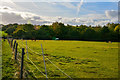
Borough of Chesterfield : Grassy Field
A grassy field with horses.
Image: © Lewis Clarke
Taken: 2 Oct 2018
0.21 miles
9
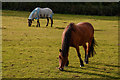
Borough of Chesterfield : Grassy Field & Horses
Horses in a field.
Image: © Lewis Clarke
Taken: 2 Oct 2018
0.21 miles
10
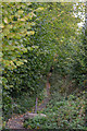
Borough of Chesterfield : Footpath
A path heading off from the road.
Image: © Lewis Clarke
Taken: 2 Oct 2018
0.22 miles